You are here: Home > Network List > TA - USArray Transportable Network (new EarthScope stations) Stations List
> Station E18A Harlowton, MT, USA > Earthquake Result Viewer
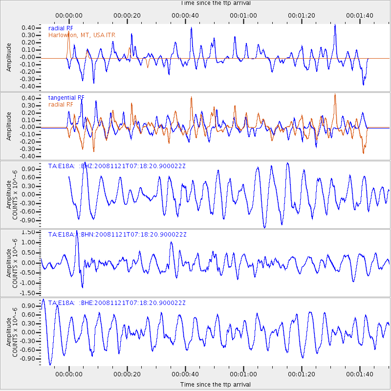
E18A Harlowton, MT, USA - Earthquake Result Viewer
*The percent match for this event was below the threshold and hence no stack was calculated.
| Earthquake location: |
Solomon Islands |
| Earthquake latitude/longitude: |
-8.9/159.6 |
| Earthquake time(UTC): |
2008/11/21 (326) 07:05:34 GMT |
| Earthquake Depth: |
118 km |
| Earthquake Magnitude: |
6.0 MB, 6.1 MW, 6.0 MW |
| Earthquake Catalog/Contributor: |
WHDF/NEIC |
|
| Network: |
TA USArray Transportable Network (new EarthScope stations) |
| Station: |
E18A Harlowton, MT, USA |
| Lat/Lon: |
46.57 N/109.91 W |
| Elevation: |
1459 m |
|
| Distance: |
96.8 deg |
| Az: |
44.01 deg |
| Baz: |
264.223 deg |
| Ray Param: |
$rayparam |
*The percent match for this event was below the threshold and hence was not used in the summary stack. |
|
| Radial Match: |
66.3764 % |
| Radial Bump: |
400 |
| Transverse Match: |
63.874443 % |
| Transverse Bump: |
395 |
| SOD ConfigId: |
2658 |
| Insert Time: |
2010-03-06 13:20:18.866 +0000 |
| GWidth: |
2.5 |
| Max Bumps: |
400 |
| Tol: |
0.001 |
|
Signal To Noise
| Channel | StoN | STA | LTA |
| TA:E18A: :BHN:20081121T07:18:20.900022Z | 1.9364105 | 7.213988E-7 | 3.7254435E-7 |
| TA:E18A: :BHE:20081121T07:18:20.900022Z | 0.46812624 | 3.054347E-7 | 6.524623E-7 |
| TA:E18A: :BHZ:20081121T07:18:20.900022Z | 0.95946264 | 4.340748E-7 | 4.524145E-7 |
| Arrivals |
| Ps | |
| PpPs | |
| PsPs/PpSs | |


