You are here: Home > Network List > TA - USArray Transportable Network (new EarthScope stations) Stations List
> Station P29M Windy Craggy, BC, CAN > Earthquake Result Viewer
P29M Windy Craggy, BC, CAN - Earthquake Result Viewer
| Earthquake location: |
Near East Coast Of Honshu, Japan |
| Earthquake latitude/longitude: |
37.2/141.2 |
| Earthquake time(UTC): |
2018/07/31 (212) 08:42:20 GMT |
| Earthquake Depth: |
10 km |
| Earthquake Magnitude: |
5.4 Mww |
| Earthquake Catalog/Contributor: |
NEIC PDE/us |
|
| Network: |
TA USArray Transportable Network (new EarthScope stations) |
| Station: |
P29M Windy Craggy, BC, CAN |
| Lat/Lon: |
59.63 N/137.74 W |
| Elevation: |
679 m |
|
| Distance: |
54.5 deg |
| Az: |
38.081 deg |
| Baz: |
284.17 deg |
| Ray Param: |
0.06542337 |
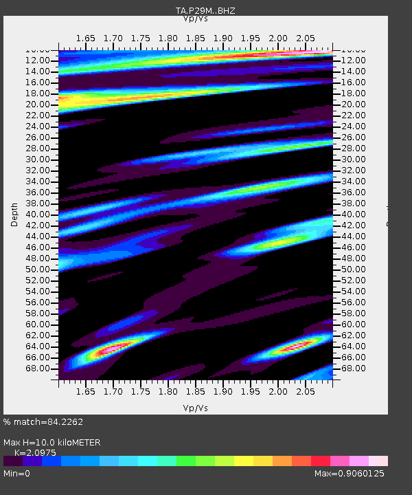
| Estimated Moho Depth: |
10.0 km |
| Estimated Crust Vp/Vs: |
2.10 |
| Assumed Crust Vp: |
6.566 km/s |
| Estimated Crust Vs: |
3.13 km/s |
| Estimated Crust Poisson's Ratio: |
0.35 |
|
| Radial Match: |
84.2262 % |
| Radial Bump: |
400 |
| Transverse Match: |
82.156746 % |
| Transverse Bump: |
400 |
| SOD ConfigId: |
13570011 |
| Insert Time: |
2019-04-30 17:00:36.863 +0000 |
| GWidth: |
2.5 |
| Max Bumps: |
400 |
| Tol: |
0.001 |
|
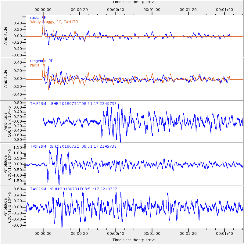
Signal To Noise
| Channel | StoN | STA | LTA |
| TA:P29M: :BHZ:20180731T08:51:17.224973Z | 7.699012 | 6.445918E-7 | 8.372397E-8 |
| TA:P29M: :BHN:20180731T08:51:17.224973Z | 1.1760539 | 1.03497946E-7 | 8.800443E-8 |
| TA:P29M: :BHE:20180731T08:51:17.224973Z | 2.5532146 | 2.3562534E-7 | 9.228575E-8 |
| Arrivals |
| Ps | 1.8 SECOND |
| PpPs | 4.5 SECOND |
| PsPs/PpSs | 6.3 SECOND |


