You are here: Home > Network List > TJ - Tajikistan National Seismic Network Stations List
> Station GARM Garm, Tajikistan > Earthquake Result Viewer
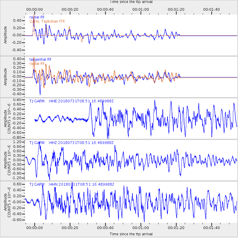
GARM Garm, Tajikistan - Earthquake Result Viewer
*The percent match for this event was below the threshold and hence no stack was calculated.
| Earthquake location: |
Near East Coast Of Honshu, Japan |
| Earthquake latitude/longitude: |
37.2/141.2 |
| Earthquake time(UTC): |
2018/07/31 (212) 08:42:20 GMT |
| Earthquake Depth: |
10 km |
| Earthquake Magnitude: |
5.4 Mww |
| Earthquake Catalog/Contributor: |
NEIC PDE/us |
|
| Network: |
TJ Tajikistan National Seismic Network |
| Station: |
GARM Garm, Tajikistan |
| Lat/Lon: |
39.00 N/70.32 E |
| Elevation: |
1305 m |
|
| Distance: |
54.5 deg |
| Az: |
295.228 deg |
| Baz: |
68.016 deg |
| Ray Param: |
$rayparam |
*The percent match for this event was below the threshold and hence was not used in the summary stack. |
|
| Radial Match: |
78.61967 % |
| Radial Bump: |
400 |
| Transverse Match: |
66.00861 % |
| Transverse Bump: |
400 |
| SOD ConfigId: |
13570011 |
| Insert Time: |
2019-04-30 17:01:05.807 +0000 |
| GWidth: |
2.5 |
| Max Bumps: |
400 |
| Tol: |
0.001 |
|
Signal To Noise
| Channel | StoN | STA | LTA |
| TJ:GARM: :HHZ:20180731T08:51:16.489988Z | 5.9828815 | 6.3786644E-7 | 1.0661525E-7 |
| TJ:GARM: :HHN:20180731T08:51:16.489988Z | 2.5952444 | 2.1793495E-7 | 8.397473E-8 |
| TJ:GARM: :HHE:20180731T08:51:16.489988Z | 5.209954 | 3.8678843E-7 | 7.424028E-8 |
| Arrivals |
| Ps | |
| PpPs | |
| PsPs/PpSs | |


