You are here: Home > Network List > CN - Canadian National Seismograph Network Stations List
> Station INK INUVIK, NT > Earthquake Result Viewer
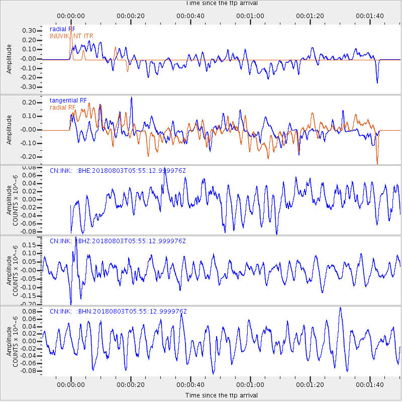
INK INUVIK, NT - Earthquake Result Viewer
*The percent match for this event was below the threshold and hence no stack was calculated.
| Earthquake location: |
Tanimbar Islands Reg., Indonesia |
| Earthquake latitude/longitude: |
-6.2/132.7 |
| Earthquake time(UTC): |
2018/08/03 (215) 05:42:14 GMT |
| Earthquake Depth: |
28 km |
| Earthquake Magnitude: |
5.4 Mww |
| Earthquake Catalog/Contributor: |
NEIC PDE/us |
|
| Network: |
CN Canadian National Seismograph Network |
| Station: |
INK INUVIK, NT |
| Lat/Lon: |
68.31 N/133.53 W |
| Elevation: |
44 m |
|
| Distance: |
97.1 deg |
| Az: |
21.954 deg |
| Baz: |
271.199 deg |
| Ray Param: |
$rayparam |
*The percent match for this event was below the threshold and hence was not used in the summary stack. |
|
| Radial Match: |
49.034534 % |
| Radial Bump: |
400 |
| Transverse Match: |
57.475525 % |
| Transverse Bump: |
400 |
| SOD ConfigId: |
13570011 |
| Insert Time: |
2019-04-30 17:05:14.640 +0000 |
| GWidth: |
2.5 |
| Max Bumps: |
400 |
| Tol: |
0.001 |
|
Signal To Noise
| Channel | StoN | STA | LTA |
| CN:INK: :BHZ:20180803T05:55:12.999976Z | 1.7612987 | 1.0599626E-7 | 6.018074E-8 |
| CN:INK: :BHN:20180803T05:55:12.999976Z | 0.91550153 | 2.722346E-8 | 2.9736116E-8 |
| CN:INK: :BHE:20180803T05:55:12.999976Z | 1.4539354 | 4.1610516E-8 | 2.8619233E-8 |
| Arrivals |
| Ps | |
| PpPs | |
| PsPs/PpSs | |


