You are here: Home > Network List > TA - USArray Transportable Network (new EarthScope stations) Stations List
> Station E18A Harlowton, MT, USA > Earthquake Result Viewer
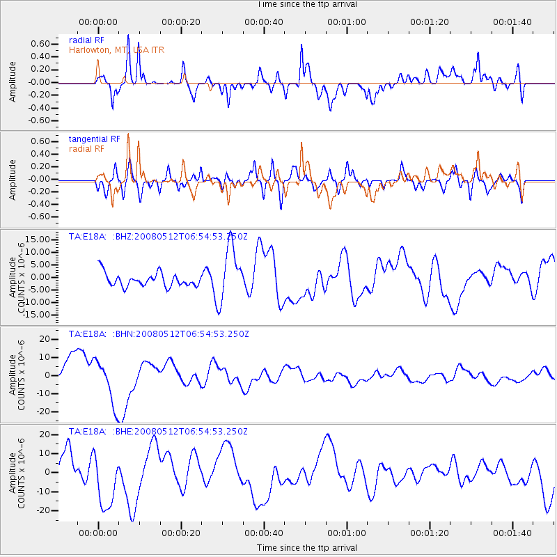
E18A Harlowton, MT, USA - Earthquake Result Viewer
*The percent match for this event was below the threshold and hence no stack was calculated.
| Earthquake location: |
Sichuan, China |
| Earthquake latitude/longitude: |
31.6/104.0 |
| Earthquake time(UTC): |
2008/05/12 (133) 06:41:56 GMT |
| Earthquake Depth: |
10 km |
| Earthquake Magnitude: |
5.7 MB |
| Earthquake Catalog/Contributor: |
WHDF/NEIC |
|
| Network: |
TA USArray Transportable Network (new EarthScope stations) |
| Station: |
E18A Harlowton, MT, USA |
| Lat/Lon: |
46.57 N/109.91 W |
| Elevation: |
1459 m |
|
| Distance: |
96.4 deg |
| Az: |
22.81 deg |
| Baz: |
331.345 deg |
| Ray Param: |
$rayparam |
*The percent match for this event was below the threshold and hence was not used in the summary stack. |
|
| Radial Match: |
54.75657 % |
| Radial Bump: |
400 |
| Transverse Match: |
52.545494 % |
| Transverse Bump: |
400 |
| SOD ConfigId: |
2504 |
| Insert Time: |
2010-03-06 13:21:17.209 +0000 |
| GWidth: |
2.5 |
| Max Bumps: |
400 |
| Tol: |
0.001 |
|
Signal To Noise
| Channel | StoN | STA | LTA |
| TA:E18A: :BHN:20080512T06:54:53.250Z | 1.5759054 | 1.255347E-5 | 7.965878E-6 |
| TA:E18A: :BHE:20080512T06:54:53.250Z | 2.085286 | 1.5324402E-5 | 7.3488254E-6 |
| TA:E18A: :BHZ:20080512T06:54:53.250Z | 4.1376777 | 1.1002853E-5 | 2.6591856E-6 |
| Arrivals |
| Ps | |
| PpPs | |
| PsPs/PpSs | |


