You are here: Home > Network List > CI - Caltech Regional Seismic Network Stations List
> Station PHL Parkhill, California, USA > Earthquake Result Viewer
PHL Parkhill, California, USA - Earthquake Result Viewer

| Earthquake location: |
Eastern Honshu, Japan |
| Earthquake latitude/longitude: |
39.4/141.1 |
| Earthquake time(UTC): |
2001/12/02 (336) 13:01:53 GMT |
| Earthquake Depth: |
124 km |
| Earthquake Magnitude: |
6.1 MB, 6.5 MW, 6.5 MW |
| Earthquake Catalog/Contributor: |
WHDF/NEIC |
|
| Network: |
CI Caltech Regional Seismic Network |
| Station: |
PHL Parkhill, California, USA |
| Lat/Lon: |
35.41 N/120.55 W |
| Elevation: |
351 m |
|
| Distance: |
74.2 deg |
| Az: |
57.14 deg |
| Baz: |
307.182 deg |
| Ray Param: |
0.05219795 |
| Estimated Moho Depth: |
24.5 km |
| Estimated Crust Vp/Vs: |
1.72 |
| Assumed Crust Vp: |
6.183 km/s |
| Estimated Crust Vs: |
3.595 km/s |
| Estimated Crust Poisson's Ratio: |
0.24 |
|
| Radial Match: |
82.22097 % |
| Radial Bump: |
392 |
| Transverse Match: |
70.14807 % |
| Transverse Bump: |
400 |
| SOD ConfigId: |
3787 |
| Insert Time: |
2010-02-26 02:07:40.766 +0000 |
| GWidth: |
2.5 |
| Max Bumps: |
400 |
| Tol: |
0.001 |
|
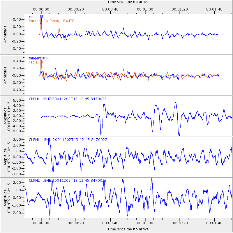
Signal To Noise
| Channel | StoN | STA | LTA |
| CI:PHL: :BHN:20011202T13:12:45.847002Z | 2.8323886 | 1.2352965E-6 | 4.361324E-7 |
| CI:PHL: :BHE:20011202T13:12:45.847002Z | 0.9390149 | 5.911534E-7 | 6.295464E-7 |
| CI:PHL: :BHZ:20011202T13:12:45.847002Z | 10.525809 | 2.4276642E-6 | 2.306392E-7 |
| Arrivals |
| Ps | 2.9 SECOND |
| PpPs | 10 SECOND |
| PsPs/PpSs | 13 SECOND |


