You are here: Home > Network List > TA - USArray Transportable Network (new EarthScope stations) Stations List
> Station E18A Harlowton, MT, USA > Earthquake Result Viewer
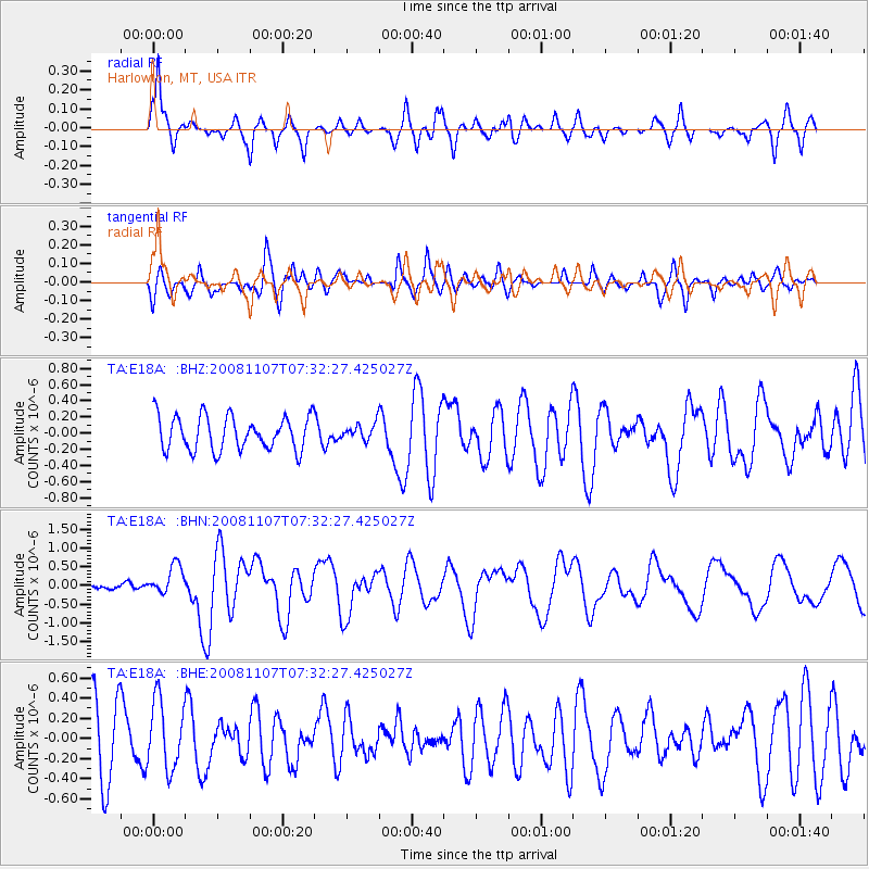
E18A Harlowton, MT, USA - Earthquake Result Viewer
*The percent match for this event was below the threshold and hence no stack was calculated.
| Earthquake location: |
Vanuatu Islands |
| Earthquake latitude/longitude: |
-14.8/168.0 |
| Earthquake time(UTC): |
2008/11/07 (312) 07:19:35 GMT |
| Earthquake Depth: |
13 km |
| Earthquake Magnitude: |
6.0 MB, 6.3 MS, 6.4 MW, 6.4 MW |
| Earthquake Catalog/Contributor: |
WHDF/NEIC |
|
| Network: |
TA USArray Transportable Network (new EarthScope stations) |
| Station: |
E18A Harlowton, MT, USA |
| Lat/Lon: |
46.57 N/109.91 W |
| Elevation: |
1459 m |
|
| Distance: |
95.3 deg |
| Az: |
43.332 deg |
| Baz: |
254.133 deg |
| Ray Param: |
$rayparam |
*The percent match for this event was below the threshold and hence was not used in the summary stack. |
|
| Radial Match: |
75.90522 % |
| Radial Bump: |
399 |
| Transverse Match: |
61.48003 % |
| Transverse Bump: |
400 |
| SOD ConfigId: |
2658 |
| Insert Time: |
2010-03-06 13:21:40.293 +0000 |
| GWidth: |
2.5 |
| Max Bumps: |
400 |
| Tol: |
0.001 |
|
Signal To Noise
| Channel | StoN | STA | LTA |
| TA:E18A: :BHN:20081107T07:32:27.425027Z | 3.2698276 | 3.8639735E-7 | 1.1817056E-7 |
| TA:E18A: :BHE:20081107T07:32:27.425027Z | 1.158585 | 3.3617994E-7 | 2.9016428E-7 |
| TA:E18A: :BHZ:20081107T07:32:27.425027Z | 0.48788053 | 1.02012976E-7 | 2.0909418E-7 |
| Arrivals |
| Ps | |
| PpPs | |
| PsPs/PpSs | |


