You are here: Home > Network List > NM - Cooperative New Madrid Seismic Network Stations List
> Station HDAR2 I40 Weigh Station,West Memphis,AR > Earthquake Result Viewer
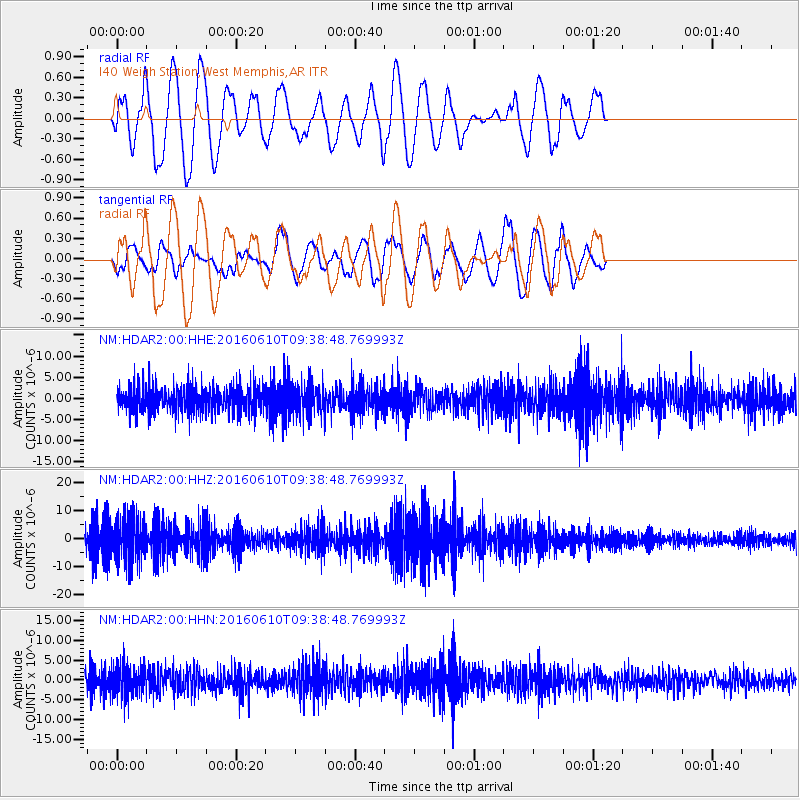
HDAR2 I40 Weigh Station,West Memphis,AR - Earthquake Result Viewer
*The percent match for this event was below the threshold and hence no stack was calculated.
| Earthquake location: |
Ascension Island Region |
| Earthquake latitude/longitude: |
-7.5/-13.6 |
| Earthquake time(UTC): |
2016/06/10 (162) 09:26:53 GMT |
| Earthquake Depth: |
10 km |
| Earthquake Magnitude: |
5.5 MWP |
| Earthquake Catalog/Contributor: |
NEIC PDE/NEIC COMCAT |
|
| Network: |
NM Cooperative New Madrid Seismic Network |
| Station: |
HDAR2 I40 Weigh Station,West Memphis,AR |
| Lat/Lon: |
35.15 N/90.09 W |
| Elevation: |
100 m |
|
| Distance: |
83.4 deg |
| Az: |
306.659 deg |
| Baz: |
103.878 deg |
| Ray Param: |
$rayparam |
*The percent match for this event was below the threshold and hence was not used in the summary stack. |
|
| Radial Match: |
59.370533 % |
| Radial Bump: |
400 |
| Transverse Match: |
50.280823 % |
| Transverse Bump: |
400 |
| SOD ConfigId: |
1609551 |
| Insert Time: |
2016-06-24 09:32:12.502 +0000 |
| GWidth: |
2.5 |
| Max Bumps: |
400 |
| Tol: |
0.001 |
|
Signal To Noise
| Channel | StoN | STA | LTA |
| NM:HDAR2:00:HHZ:20160610T09:38:48.769993Z | 2.2366724 | 7.738986E-6 | 3.4600446E-6 |
| NM:HDAR2:00:HHN:20160610T09:38:48.769993Z | 1.7549456 | 3.9073134E-6 | 2.2264583E-6 |
| NM:HDAR2:00:HHE:20160610T09:38:48.769993Z | 1.2106901 | 3.73296E-6 | 3.0833323E-6 |
| Arrivals |
| Ps | |
| PpPs | |
| PsPs/PpSs | |


