You are here: Home > Network List > TA - USArray Transportable Network (new EarthScope stations) Stations List
> Station S23A Nye Farm, Monte Vista, CO, USA > Earthquake Result Viewer
S23A Nye Farm, Monte Vista, CO, USA - Earthquake Result Viewer

| Earthquake location: |
Kuril Islands |
| Earthquake latitude/longitude: |
51.0/157.6 |
| Earthquake time(UTC): |
2008/07/24 (206) 01:43:16 GMT |
| Earthquake Depth: |
27 km |
| Earthquake Magnitude: |
6.0 MB, 6.0 MS, 6.2 MW, 6.2 MW |
| Earthquake Catalog/Contributor: |
WHDF/NEIC |
|
| Network: |
TA USArray Transportable Network (new EarthScope stations) |
| Station: |
S23A Nye Farm, Monte Vista, CO, USA |
| Lat/Lon: |
37.71 N/106.00 W |
| Elevation: |
2323 m |
|
| Distance: |
65.4 deg |
| Az: |
60.072 deg |
| Baz: |
316.297 deg |
| Ray Param: |
0.058238685 |
| Estimated Moho Depth: |
47.0 km |
| Estimated Crust Vp/Vs: |
1.71 |
| Assumed Crust Vp: |
6.159 km/s |
| Estimated Crust Vs: |
3.602 km/s |
| Estimated Crust Poisson's Ratio: |
0.24 |
|
| Radial Match: |
85.454605 % |
| Radial Bump: |
400 |
| Transverse Match: |
79.764885 % |
| Transverse Bump: |
400 |
| SOD ConfigId: |
2504 |
| Insert Time: |
2010-03-06 13:21:58.628 +0000 |
| GWidth: |
2.5 |
| Max Bumps: |
400 |
| Tol: |
0.001 |
|
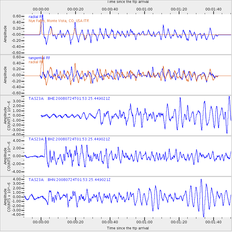
Signal To Noise
| Channel | StoN | STA | LTA |
| TA:S23A: :BHZ:20080724T01:53:25.449021Z | 15.679713 | 1.8413008E-6 | 1.17432045E-7 |
| TA:S23A: :BHN:20080724T01:53:25.449021Z | 2.2438362 | 6.534826E-7 | 2.9123453E-7 |
| TA:S23A: :BHE:20080724T01:53:25.449021Z | 3.1488018 | 7.2302834E-7 | 2.2962014E-7 |
| Arrivals |
| Ps | 5.6 SECOND |
| PpPs | 20 SECOND |
| PsPs/PpSs | 26 SECOND |


