You are here: Home > Network List > TA - USArray Transportable Network (new EarthScope stations) Stations List
> Station S23A Nye Farm, Monte Vista, CO, USA > Earthquake Result Viewer
S23A Nye Farm, Monte Vista, CO, USA - Earthquake Result Viewer
| Earthquake location: |
Tonga Islands |
| Earthquake latitude/longitude: |
-21.9/-173.8 |
| Earthquake time(UTC): |
2008/10/19 (293) 05:10:33 GMT |
| Earthquake Depth: |
29 km |
| Earthquake Magnitude: |
6.8 MB, 7.0 MS, 6.9 MW, 6.9 MW |
| Earthquake Catalog/Contributor: |
WHDF/NEIC |
|
| Network: |
TA USArray Transportable Network (new EarthScope stations) |
| Station: |
S23A Nye Farm, Monte Vista, CO, USA |
| Lat/Lon: |
37.71 N/106.00 W |
| Elevation: |
2323 m |
|
| Distance: |
87.0 deg |
| Az: |
47.346 deg |
| Baz: |
239.471 deg |
| Ray Param: |
0.04362151 |
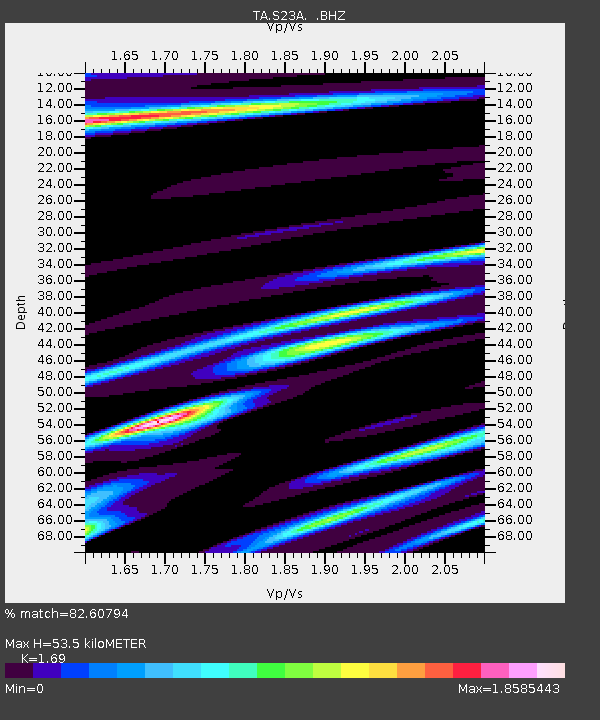
| Estimated Moho Depth: |
53.5 km |
| Estimated Crust Vp/Vs: |
1.69 |
| Assumed Crust Vp: |
6.159 km/s |
| Estimated Crust Vs: |
3.644 km/s |
| Estimated Crust Poisson's Ratio: |
0.23 |
|
| Radial Match: |
82.60794 % |
| Radial Bump: |
400 |
| Transverse Match: |
80.15181 % |
| Transverse Bump: |
393 |
| SOD ConfigId: |
2556 |
| Insert Time: |
2010-03-06 13:22:04.318 +0000 |
| GWidth: |
2.5 |
| Max Bumps: |
400 |
| Tol: |
0.001 |
|

Signal To Noise
| Channel | StoN | STA | LTA |
| TA:S23A: :BHZ:20081019T05:22:44.975002Z | 43.788513 | 6.3130815E-6 | 1.4417209E-7 |
| TA:S23A: :BHN:20081019T05:22:44.975002Z | 3.1517723 | 9.5186243E-7 | 3.0200863E-7 |
| TA:S23A: :BHE:20081019T05:22:44.975002Z | 4.697424 | 1.3193592E-6 | 2.8086865E-7 |
| Arrivals |
| Ps | 6.1 SECOND |
| PpPs | 23 SECOND |
| PsPs/PpSs | 29 SECOND |


