You are here: Home > Network List > TA - USArray Transportable Network (new EarthScope stations) Stations List
> Station S23A Nye Farm, Monte Vista, CO, USA > Earthquake Result Viewer
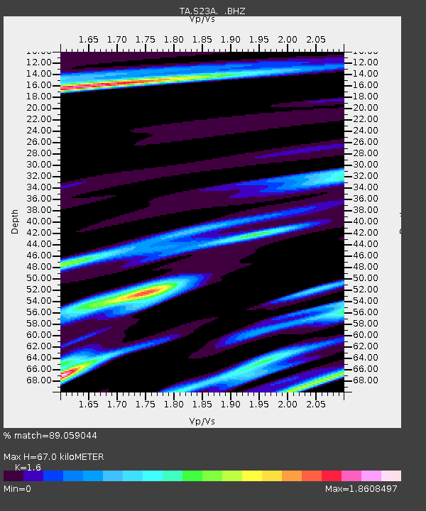
S23A Nye Farm, Monte Vista, CO, USA - Earthquake Result Viewer
| Earthquake location: |
Kermadec Islands Region |
| Earthquake latitude/longitude: |
-27.4/-176.3 |
| Earthquake time(UTC): |
2009/02/18 (049) 21:53:45 GMT |
| Earthquake Depth: |
25 km |
| Earthquake Magnitude: |
6.8 MB, 7.2 MS, 6.9 MW, 6.9 MW |
| Earthquake Catalog/Contributor: |
WHDF/NEIC |
|
| Network: |
TA USArray Transportable Network (new EarthScope stations) |
| Station: |
S23A Nye Farm, Monte Vista, CO, USA |
| Lat/Lon: |
37.71 N/106.00 W |
| Elevation: |
2323 m |
|
| Distance: |
92.4 deg |
| Az: |
48.374 deg |
| Baz: |
236.901 deg |
| Ray Param: |
0.041460246 |
| Estimated Moho Depth: |
67.0 km |
| Estimated Crust Vp/Vs: |
1.60 |
| Assumed Crust Vp: |
6.159 km/s |
| Estimated Crust Vs: |
3.849 km/s |
| Estimated Crust Poisson's Ratio: |
0.18 |
|
| Radial Match: |
89.059044 % |
| Radial Bump: |
378 |
| Transverse Match: |
82.39357 % |
| Transverse Bump: |
350 |
| SOD ConfigId: |
2658 |
| Insert Time: |
2010-03-06 13:22:13.317 +0000 |
| GWidth: |
2.5 |
| Max Bumps: |
400 |
| Tol: |
0.001 |
|

Signal To Noise
| Channel | StoN | STA | LTA |
| TA:S23A: :BHZ:20090218T22:06:22.000027Z | 7.46574 | 1.62888E-6 | 2.1818065E-7 |
| TA:S23A: :BHN:20090218T22:06:22.000027Z | 1.2908825 | 6.5151113E-7 | 5.0470214E-7 |
| TA:S23A: :BHE:20090218T22:06:22.000027Z | 0.9122414 | 6.708253E-7 | 7.353594E-7 |
| Arrivals |
| Ps | 6.7 SECOND |
| PpPs | 28 SECOND |
| PsPs/PpSs | 34 SECOND |


