You are here: Home > Network List > JP - Japan Meteorological Agency Seismic Network Stations List
> Station JWT Kyoto Wachi > Earthquake Result Viewer
JWT Kyoto Wachi - Earthquake Result Viewer
| Earthquake location: |
Southern Sumatra, Indonesia |
| Earthquake latitude/longitude: |
-2.4/99.3 |
| Earthquake time(UTC): |
2018/08/05 (217) 08:56:22 GMT |
| Earthquake Depth: |
10 km |
| Earthquake Magnitude: |
5.5 mb |
| Earthquake Catalog/Contributor: |
NEIC PDE/us |
|
| Network: |
JP Japan Meteorological Agency Seismic Network |
| Station: |
JWT Kyoto Wachi |
| Lat/Lon: |
35.29 N/135.40 E |
| Elevation: |
172 m |
|
| Distance: |
50.5 deg |
| Az: |
38.632 deg |
| Baz: |
229.68 deg |
| Ray Param: |
0.068037294 |
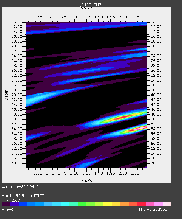
| Estimated Moho Depth: |
53.5 km |
| Estimated Crust Vp/Vs: |
2.07 |
| Assumed Crust Vp: |
6.468 km/s |
| Estimated Crust Vs: |
3.125 km/s |
| Estimated Crust Poisson's Ratio: |
0.35 |
|
| Radial Match: |
89.10411 % |
| Radial Bump: |
400 |
| Transverse Match: |
52.820274 % |
| Transverse Bump: |
400 |
| SOD ConfigId: |
13570011 |
| Insert Time: |
2019-04-30 17:17:29.092 +0000 |
| GWidth: |
2.5 |
| Max Bumps: |
400 |
| Tol: |
0.001 |
|

Signal To Noise
| Channel | StoN | STA | LTA |
| JP:JWT: :BHZ:20180805T09:04:49.199989Z | 1.0018052 | 1.7666466E-8 | 1.7634633E-8 |
| JP:JWT: :BHN:20180805T09:04:49.199989Z | 0.9278481 | 2.0884446E-8 | 2.2508477E-8 |
| JP:JWT: :BHE:20180805T09:04:49.199989Z | 1.0702546 | 1.7028688E-8 | 1.5910876E-8 |
| Arrivals |
| Ps | 9.3 SECOND |
| PpPs | 24 SECOND |
| PsPs/PpSs | 33 SECOND |


