You are here: Home > Network List > TA - USArray Transportable Network (new EarthScope stations) Stations List
> Station S23A Nye Farm, Monte Vista, CO, USA > Earthquake Result Viewer
S23A Nye Farm, Monte Vista, CO, USA - Earthquake Result Viewer
| Earthquake location: |
Tonga Islands |
| Earthquake latitude/longitude: |
-20.8/-174.3 |
| Earthquake time(UTC): |
2009/07/30 (211) 20:05:34 GMT |
| Earthquake Depth: |
10 km |
| Earthquake Magnitude: |
5.9 MB, 5.7 MS, 5.8 MW, 5.7 MW |
| Earthquake Catalog/Contributor: |
WHDF/NEIC |
|
| Network: |
TA USArray Transportable Network (new EarthScope stations) |
| Station: |
S23A Nye Farm, Monte Vista, CO, USA |
| Lat/Lon: |
37.71 N/106.00 W |
| Elevation: |
2323 m |
|
| Distance: |
86.6 deg |
| Az: |
47.56 deg |
| Baz: |
240.491 deg |
| Ray Param: |
0.04393862 |
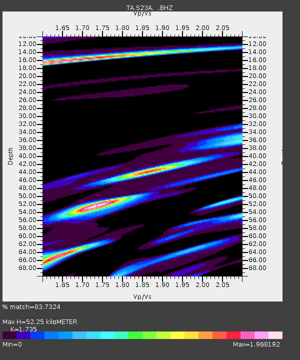
| Estimated Moho Depth: |
52.25 km |
| Estimated Crust Vp/Vs: |
1.74 |
| Assumed Crust Vp: |
6.159 km/s |
| Estimated Crust Vs: |
3.55 km/s |
| Estimated Crust Poisson's Ratio: |
0.25 |
|
| Radial Match: |
83.7324 % |
| Radial Bump: |
313 |
| Transverse Match: |
82.3837 % |
| Transverse Bump: |
312 |
| SOD ConfigId: |
2622 |
| Insert Time: |
2010-03-06 13:22:14.620 +0000 |
| GWidth: |
2.5 |
| Max Bumps: |
400 |
| Tol: |
0.001 |
|
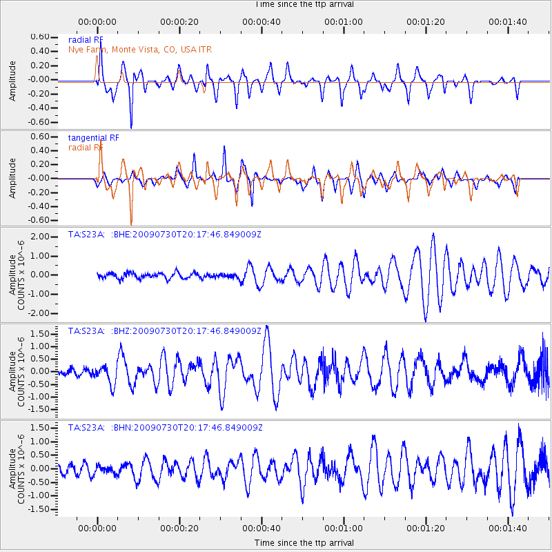
Signal To Noise
| Channel | StoN | STA | LTA |
| TA:S23A: :BHZ:20090730T20:17:46.849009Z | 3.635242 | 3.8430164E-7 | 1.0571556E-7 |
| TA:S23A: :BHN:20090730T20:17:46.849009Z | 0.74988693 | 1.4138107E-7 | 1.8853652E-7 |
| TA:S23A: :BHE:20090730T20:17:46.849009Z | 0.77560925 | 1.1175298E-7 | 1.4408413E-7 |
| Arrivals |
| Ps | 6.4 SECOND |
| PpPs | 23 SECOND |
| PsPs/PpSs | 29 SECOND |


