You are here: Home > Network List > TA - USArray Transportable Network (new EarthScope stations) Stations List
> Station S23A Nye Farm, Monte Vista, CO, USA > Earthquake Result Viewer
S23A Nye Farm, Monte Vista, CO, USA - Earthquake Result Viewer

| Earthquake location: |
Samoa Islands Region |
| Earthquake latitude/longitude: |
-15.2/-172.6 |
| Earthquake time(UTC): |
2009/08/30 (242) 14:51:32 GMT |
| Earthquake Depth: |
11 km |
| Earthquake Magnitude: |
6.4 MB, 6.3 MS, 6.6 MW, 6.6 MW |
| Earthquake Catalog/Contributor: |
WHDF/NEIC |
|
| Network: |
TA USArray Transportable Network (new EarthScope stations) |
| Station: |
S23A Nye Farm, Monte Vista, CO, USA |
| Lat/Lon: |
37.71 N/106.00 W |
| Elevation: |
2323 m |
|
| Distance: |
81.6 deg |
| Az: |
47.355 deg |
| Baz: |
243.545 deg |
| Ray Param: |
0.047449052 |
| Estimated Moho Depth: |
52.0 km |
| Estimated Crust Vp/Vs: |
1.73 |
| Assumed Crust Vp: |
6.159 km/s |
| Estimated Crust Vs: |
3.555 km/s |
| Estimated Crust Poisson's Ratio: |
0.25 |
|
| Radial Match: |
88.93436 % |
| Radial Bump: |
400 |
| Transverse Match: |
81.80402 % |
| Transverse Bump: |
400 |
| SOD ConfigId: |
2622 |
| Insert Time: |
2010-03-06 13:22:24.614 +0000 |
| GWidth: |
2.5 |
| Max Bumps: |
400 |
| Tol: |
0.001 |
|
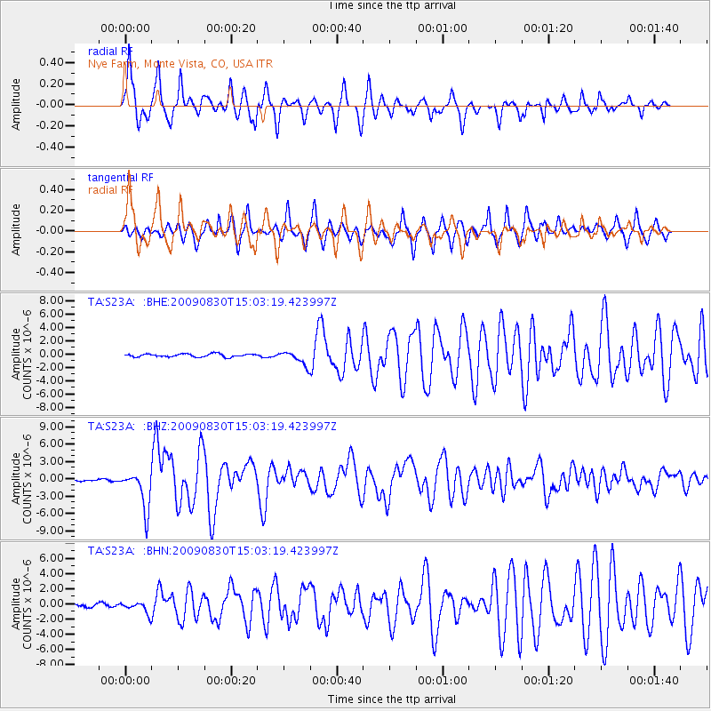
Signal To Noise
| Channel | StoN | STA | LTA |
| TA:S23A: :BHZ:20090830T15:03:19.423997Z | 26.600655 | 3.3791025E-6 | 1.270308E-7 |
| TA:S23A: :BHN:20090830T15:03:19.423997Z | 2.222986 | 7.5722573E-7 | 3.406345E-7 |
| TA:S23A: :BHE:20090830T15:03:19.423997Z | 4.680376 | 1.0753029E-6 | 2.297471E-7 |
| Arrivals |
| Ps | 6.3 SECOND |
| PpPs | 22 SECOND |
| PsPs/PpSs | 29 SECOND |


