You are here: Home > Network List > 2H - Interim Broadband Monitoring of the Mount Erebus Volcano Stations List
> Station NAUS Mt Erebus site NAUS > Earthquake Result Viewer
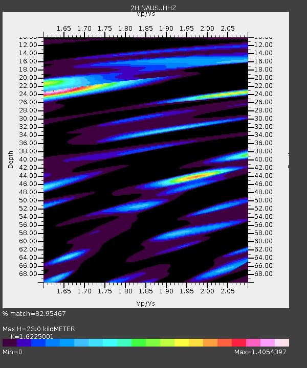
NAUS Mt Erebus site NAUS - Earthquake Result Viewer
| Earthquake location: |
Sumbawa Region, Indonesia |
| Earthquake latitude/longitude: |
-8.3/116.5 |
| Earthquake time(UTC): |
2018/08/05 (217) 11:46:34 GMT |
| Earthquake Depth: |
10 km |
| Earthquake Magnitude: |
7.0 Mww |
| Earthquake Catalog/Contributor: |
NEIC PDE/us |
|
| Network: |
2H Interim Broadband Monitoring of the Mount Erebus Volcano |
| Station: |
NAUS Mt Erebus site NAUS |
| Lat/Lon: |
77.52 S/167.15 E |
| Elevation: |
3590 m |
|
| Distance: |
74.0 deg |
| Az: |
169.919 deg |
| Baz: |
307.182 deg |
| Ray Param: |
0.052632723 |
| Estimated Moho Depth: |
23.0 km |
| Estimated Crust Vp/Vs: |
1.62 |
| Assumed Crust Vp: |
6.183 km/s |
| Estimated Crust Vs: |
3.811 km/s |
| Estimated Crust Poisson's Ratio: |
0.19 |
|
| Radial Match: |
82.95467 % |
| Radial Bump: |
400 |
| Transverse Match: |
80.85549 % |
| Transverse Bump: |
400 |
| SOD ConfigId: |
13570011 |
| Insert Time: |
2019-04-30 17:19:44.048 +0000 |
| GWidth: |
2.5 |
| Max Bumps: |
400 |
| Tol: |
0.001 |
|

Signal To Noise
| Channel | StoN | STA | LTA |
| 2H:NAUS: :HHZ:20180805T11:57:39.708987Z | 16.722387 | 4.858595E-6 | 2.9054434E-7 |
| 2H:NAUS: :HH1:20180805T11:57:39.708987Z | 9.00778 | 2.0593081E-6 | 2.286144E-7 |
| 2H:NAUS: :HH2:20180805T11:57:39.708987Z | 8.663807 | 2.2188117E-6 | 2.5610123E-7 |
| Arrivals |
| Ps | 2.4 SECOND |
| PpPs | 9.4 SECOND |
| PsPs/PpSs | 12 SECOND |


