You are here: Home > Network List > AF - Africa Array Stations List
> Station TEBE Entebbe, Uganda > Earthquake Result Viewer
TEBE Entebbe, Uganda - Earthquake Result Viewer
| Earthquake location: |
Sumbawa Region, Indonesia |
| Earthquake latitude/longitude: |
-8.3/116.5 |
| Earthquake time(UTC): |
2018/08/05 (217) 11:46:34 GMT |
| Earthquake Depth: |
10 km |
| Earthquake Magnitude: |
7.0 Mww |
| Earthquake Catalog/Contributor: |
NEIC PDE/us |
|
| Network: |
AF Africa Array |
| Station: |
TEBE Entebbe, Uganda |
| Lat/Lon: |
0.05 N/32.48 E |
| Elevation: |
1132 m |
|
| Distance: |
84.0 deg |
| Az: |
270.917 deg |
| Baz: |
98.264 deg |
| Ray Param: |
0.04575672 |
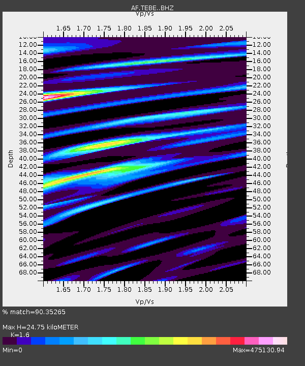
| Estimated Moho Depth: |
24.75 km |
| Estimated Crust Vp/Vs: |
1.60 |
| Assumed Crust Vp: |
6.642 km/s |
| Estimated Crust Vs: |
4.151 km/s |
| Estimated Crust Poisson's Ratio: |
0.18 |
|
| Radial Match: |
90.35265 % |
| Radial Bump: |
400 |
| Transverse Match: |
90.35264 % |
| Transverse Bump: |
400 |
| SOD ConfigId: |
13570011 |
| Insert Time: |
2019-04-30 17:19:49.601 +0000 |
| GWidth: |
2.5 |
| Max Bumps: |
400 |
| Tol: |
0.001 |
|

Signal To Noise
| Channel | StoN | STA | LTA |
| AF:TEBE: :BHZ:20180805T11:58:34.364993Z | 9.630107 | 2.4809339E-12 | 2.5762267E-13 |
| AF:TEBE: :BHN:20180805T11:58:34.364993Z | 1.0946385 | 1.4853227E-13 | 1.3569071E-13 |
| AF:TEBE: :BHE:20180805T11:58:34.364993Z | 3.628047 | 9.387791E-7 | 2.5875605E-7 |
| Arrivals |
| Ps | 2.3 SECOND |
| PpPs | 9.4 SECOND |
| PsPs/PpSs | 12 SECOND |


