You are here: Home > Network List > TA - USArray Transportable Network (new EarthScope stations) Stations List
> Station S23A Nye Farm, Monte Vista, CO, USA > Earthquake Result Viewer
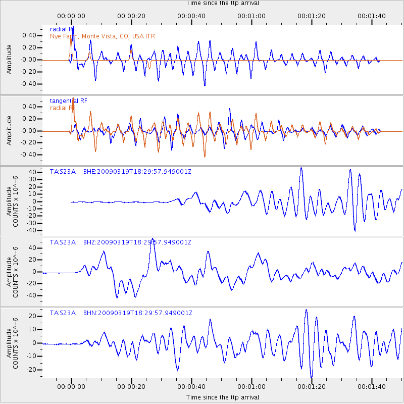
S23A Nye Farm, Monte Vista, CO, USA - Earthquake Result Viewer
| Earthquake location: |
Tonga Islands Region |
| Earthquake latitude/longitude: |
-23.0/-174.7 |
| Earthquake time(UTC): |
2009/03/19 (078) 18:17:40 GMT |
| Earthquake Depth: |
34 km |
| Earthquake Magnitude: |
7.0 MB, 7.6 MS, 7.6 MW, 7.6 MW |
| Earthquake Catalog/Contributor: |
WHDF/NEIC |
|
| Network: |
TA USArray Transportable Network (new EarthScope stations) |
| Station: |
S23A Nye Farm, Monte Vista, CO, USA |
| Lat/Lon: |
37.71 N/106.00 W |
| Elevation: |
2323 m |
|
| Distance: |
88.3 deg |
| Az: |
47.651 deg |
| Baz: |
239.128 deg |
| Ray Param: |
0.04260947 |
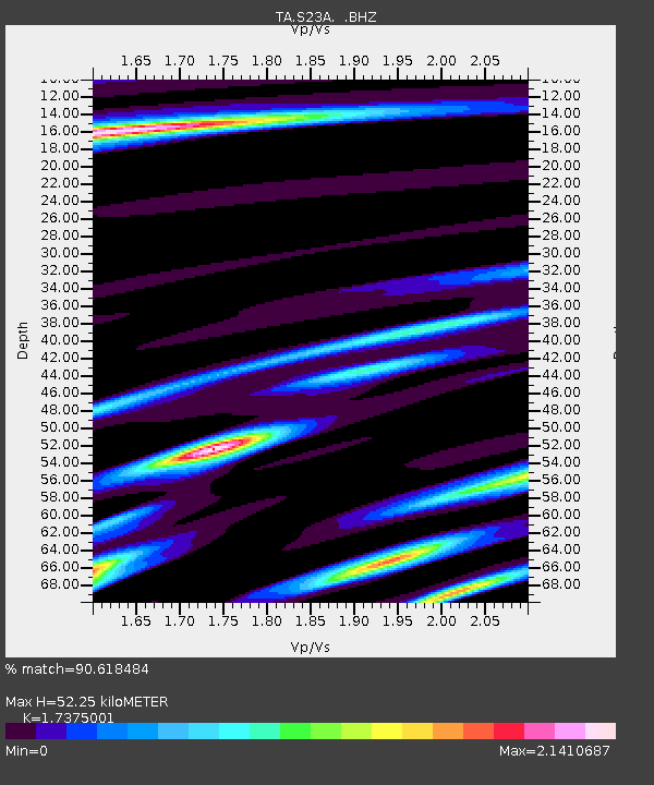
| Estimated Moho Depth: |
52.25 km |
| Estimated Crust Vp/Vs: |
1.74 |
| Assumed Crust Vp: |
6.159 km/s |
| Estimated Crust Vs: |
3.545 km/s |
| Estimated Crust Poisson's Ratio: |
0.25 |
|
| Radial Match: |
90.618484 % |
| Radial Bump: |
400 |
| Transverse Match: |
83.72014 % |
| Transverse Bump: |
400 |
| SOD ConfigId: |
2658 |
| Insert Time: |
2010-03-06 13:22:31.336 +0000 |
| GWidth: |
2.5 |
| Max Bumps: |
400 |
| Tol: |
0.001 |
|
Signal To Noise
| Channel | StoN | STA | LTA |
| TA:S23A: :BHZ:20090319T18:29:57.949001Z | 17.177244 | 5.200902E-6 | 3.027786E-7 |
| TA:S23A: :BHN:20090319T18:29:57.949001Z | 2.597729 | 6.7047745E-7 | 2.5810138E-7 |
| TA:S23A: :BHE:20090319T18:29:57.949001Z | 3.183755 | 1.3615892E-6 | 4.2766771E-7 |
| Arrivals |
| Ps | 6.4 SECOND |
| PpPs | 23 SECOND |
| PsPs/PpSs | 29 SECOND |


