You are here: Home > Network List > AU - Australian Seismological Centre Stations List
> Station TOO Toolangi, Victoria > Earthquake Result Viewer
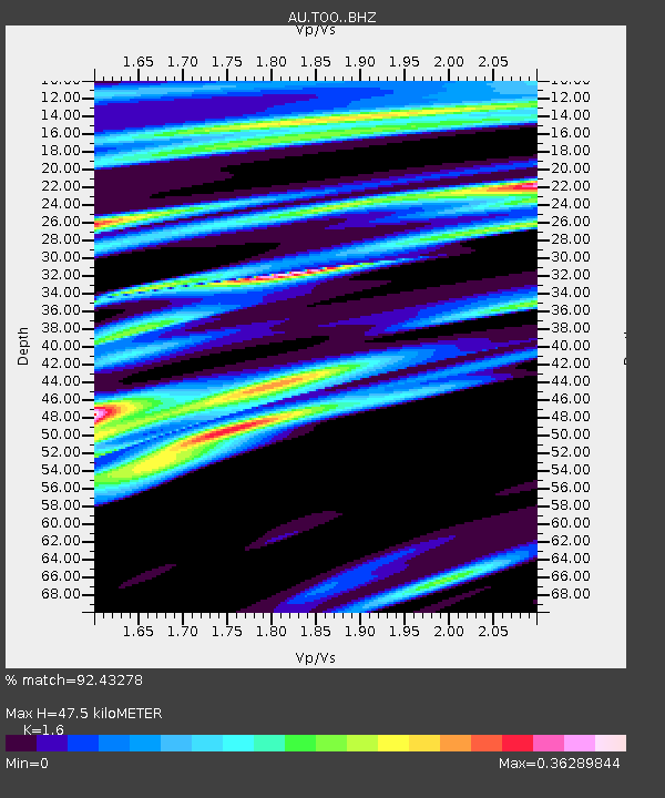
TOO Toolangi, Victoria - Earthquake Result Viewer
| Earthquake location: |
Sumbawa Region, Indonesia |
| Earthquake latitude/longitude: |
-8.3/116.5 |
| Earthquake time(UTC): |
2018/08/05 (217) 11:46:34 GMT |
| Earthquake Depth: |
10 km |
| Earthquake Magnitude: |
7.0 Mww |
| Earthquake Catalog/Contributor: |
NEIC PDE/us |
|
| Network: |
AU Australian Seismological Centre |
| Station: |
TOO Toolangi, Victoria |
| Lat/Lon: |
37.57 S/145.49 E |
| Elevation: |
604 m |
|
| Distance: |
39.3 deg |
| Az: |
142.453 deg |
| Baz: |
310.615 deg |
| Ray Param: |
0.075088665 |
| Estimated Moho Depth: |
47.5 km |
| Estimated Crust Vp/Vs: |
1.60 |
| Assumed Crust Vp: |
6.577 km/s |
| Estimated Crust Vs: |
4.11 km/s |
| Estimated Crust Poisson's Ratio: |
0.18 |
|
| Radial Match: |
92.43278 % |
| Radial Bump: |
257 |
| Transverse Match: |
65.99866 % |
| Transverse Bump: |
400 |
| SOD ConfigId: |
13570011 |
| Insert Time: |
2019-04-30 17:20:10.489 +0000 |
| GWidth: |
2.5 |
| Max Bumps: |
400 |
| Tol: |
0.001 |
|

Signal To Noise
| Channel | StoN | STA | LTA |
| AU:TOO: :BHZ:20180805T11:53:33.519015Z | 5.5327973 | 5.0987255E-6 | 9.2154573E-7 |
| AU:TOO: :BHN:20180805T11:53:33.519015Z | 4.454086 | 1.5970792E-6 | 3.58565E-7 |
| AU:TOO: :BHE:20180805T11:53:33.519015Z | 4.2494435 | 2.081596E-6 | 4.8985146E-7 |
| Arrivals |
| Ps | 4.7 SECOND |
| PpPs | 17 SECOND |
| PsPs/PpSs | 22 SECOND |


