You are here: Home > Network List > JP - Japan Meteorological Agency Seismic Network Stations List
> Station JTU Tsushima Kamiagata > Earthquake Result Viewer
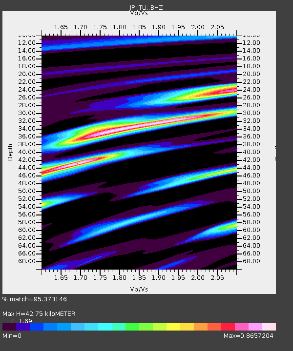
JTU Tsushima Kamiagata - Earthquake Result Viewer
| Earthquake location: |
Sumbawa Region, Indonesia |
| Earthquake latitude/longitude: |
-8.3/116.5 |
| Earthquake time(UTC): |
2018/08/05 (217) 11:46:34 GMT |
| Earthquake Depth: |
10 km |
| Earthquake Magnitude: |
7.0 Mww |
| Earthquake Catalog/Contributor: |
NEIC PDE/us |
|
| Network: |
JP Japan Meteorological Agency Seismic Network |
| Station: |
JTU Tsushima Kamiagata |
| Lat/Lon: |
34.53 N/129.40 E |
| Elevation: |
70 m |
|
| Distance: |
44.3 deg |
| Az: |
15.352 deg |
| Baz: |
198.504 deg |
| Ray Param: |
0.07200597 |
| Estimated Moho Depth: |
42.75 km |
| Estimated Crust Vp/Vs: |
1.69 |
| Assumed Crust Vp: |
6.472 km/s |
| Estimated Crust Vs: |
3.83 km/s |
| Estimated Crust Poisson's Ratio: |
0.23 |
|
| Radial Match: |
95.373146 % |
| Radial Bump: |
387 |
| Transverse Match: |
87.73162 % |
| Transverse Bump: |
400 |
| SOD ConfigId: |
13570011 |
| Insert Time: |
2019-04-30 17:21:30.930 +0000 |
| GWidth: |
2.5 |
| Max Bumps: |
400 |
| Tol: |
0.001 |
|

Signal To Noise
| Channel | StoN | STA | LTA |
| JP:JTU: :BHZ:20180805T11:54:14.450015Z | 13.2464285 | 2.1088447E-6 | 1.5920101E-7 |
| JP:JTU: :BHN:20180805T11:54:14.450015Z | 8.431317 | 1.177121E-6 | 1.3961295E-7 |
| JP:JTU: :BHE:20180805T11:54:14.450015Z | 3.200372 | 5.595276E-7 | 1.7483207E-7 |
| Arrivals |
| Ps | 4.9 SECOND |
| PpPs | 17 SECOND |
| PsPs/PpSs | 21 SECOND |


