You are here: Home > Network List > S - Seismographs in Schools Projects Stations List
> Station AUPKL Parklands High School, Burnie, TAS > Earthquake Result Viewer
AUPKL Parklands High School, Burnie, TAS - Earthquake Result Viewer
| Earthquake location: |
Sumbawa Region, Indonesia |
| Earthquake latitude/longitude: |
-8.3/116.5 |
| Earthquake time(UTC): |
2018/08/05 (217) 11:46:34 GMT |
| Earthquake Depth: |
10 km |
| Earthquake Magnitude: |
7.0 Mww |
| Earthquake Catalog/Contributor: |
NEIC PDE/us |
|
| Network: |
S Seismographs in Schools Projects |
| Station: |
AUPKL Parklands High School, Burnie, TAS |
| Lat/Lon: |
41.08 S/145.90 E |
| Elevation: |
171 m |
|
| Distance: |
41.8 deg |
| Az: |
146.14 deg |
| Baz: |
313.159 deg |
| Ray Param: |
0.07353988 |
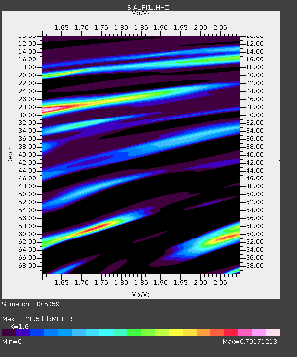
| Estimated Moho Depth: |
28.5 km |
| Estimated Crust Vp/Vs: |
1.60 |
| Assumed Crust Vp: |
6.477 km/s |
| Estimated Crust Vs: |
4.048 km/s |
| Estimated Crust Poisson's Ratio: |
0.18 |
|
| Radial Match: |
80.5059 % |
| Radial Bump: |
279 |
| Transverse Match: |
53.956768 % |
| Transverse Bump: |
400 |
| SOD ConfigId: |
13570011 |
| Insert Time: |
2019-04-30 17:22:31.075 +0000 |
| GWidth: |
2.5 |
| Max Bumps: |
400 |
| Tol: |
0.001 |
|

Signal To Noise
| Channel | StoN | STA | LTA |
| S:AUPKL: :HHZ:20180805T11:53:54.760012Z | 3.8071544 | 4.569493E-6 | 1.2002384E-6 |
| S:AUPKL: :HHN:20180805T11:53:54.760012Z | 2.3675556 | 2.463473E-6 | 1.0405132E-6 |
| S:AUPKL: :HHE:20180805T11:53:54.760012Z | 1.5275397 | 2.3653056E-6 | 1.5484412E-6 |
| Arrivals |
| Ps | 2.9 SECOND |
| PpPs | 11 SECOND |
| PsPs/PpSs | 13 SECOND |


