You are here: Home > Network List > TA - USArray Transportable Network (new EarthScope stations) Stations List
> Station B18K Kokolik River, AK, USA > Earthquake Result Viewer
B18K Kokolik River, AK, USA - Earthquake Result Viewer
| Earthquake location: |
Sumbawa Region, Indonesia |
| Earthquake latitude/longitude: |
-8.3/116.5 |
| Earthquake time(UTC): |
2018/08/05 (217) 11:46:34 GMT |
| Earthquake Depth: |
10 km |
| Earthquake Magnitude: |
7.0 Mww |
| Earthquake Catalog/Contributor: |
NEIC PDE/us |
|
| Network: |
TA USArray Transportable Network (new EarthScope stations) |
| Station: |
B18K Kokolik River, AK, USA |
| Lat/Lon: |
69.36 N/161.80 W |
| Elevation: |
222 m |
|
| Distance: |
94.8 deg |
| Az: |
20.613 deg |
| Baz: |
259.384 deg |
| Ray Param: |
0.04095911 |
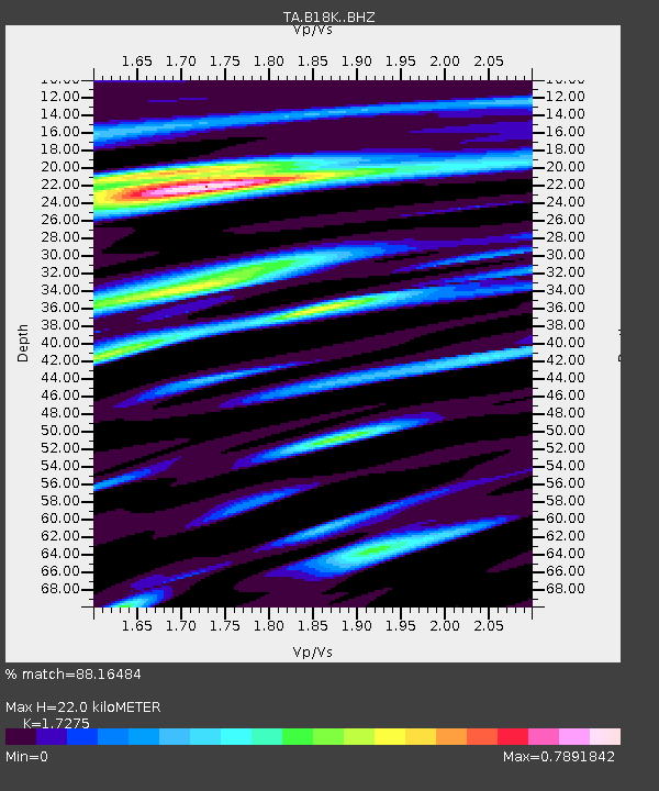
| Estimated Moho Depth: |
22.0 km |
| Estimated Crust Vp/Vs: |
1.73 |
| Assumed Crust Vp: |
5.906 km/s |
| Estimated Crust Vs: |
3.419 km/s |
| Estimated Crust Poisson's Ratio: |
0.25 |
|
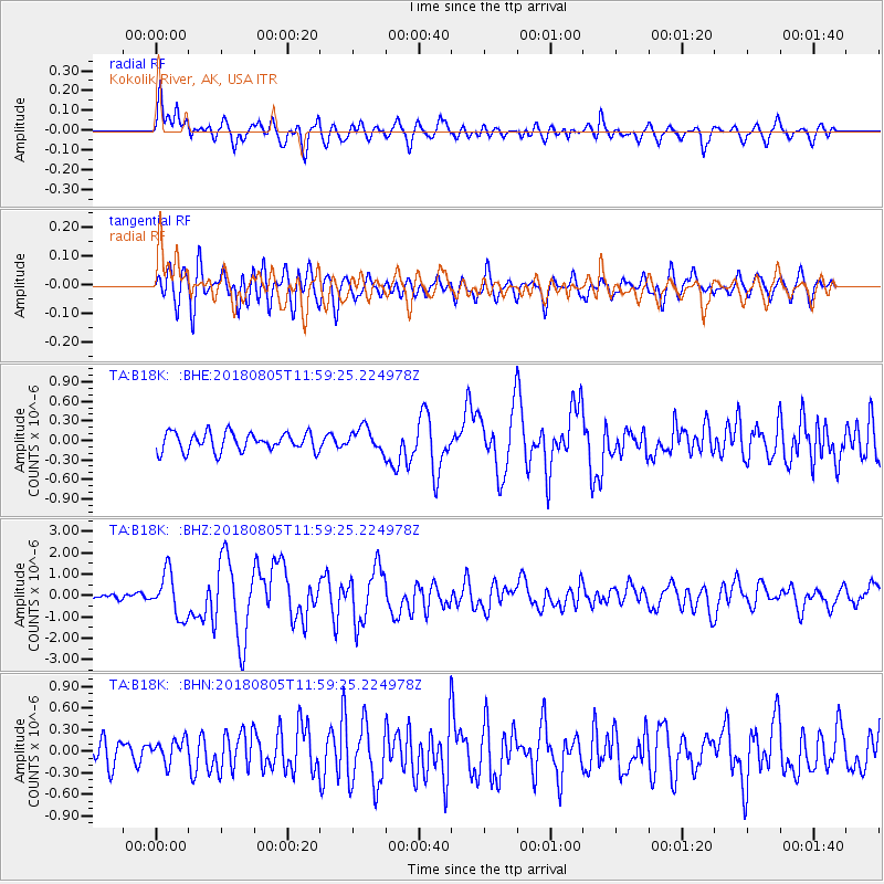
| Radial Match: |
88.16484 % |
| Radial Bump: |
400 |
| Transverse Match: |
78.41523 % |
| Transverse Bump: |
400 |
| SOD ConfigId: |
13570011 |
| Insert Time: |
2019-04-30 17:22:41.473 +0000 |
| GWidth: |
2.5 |
| Max Bumps: |
400 |
| Tol: |
0.001 |
|
Signal To Noise
| Channel | StoN | STA | LTA |
| TA:B18K: :BHZ:20180805T11:59:25.224978Z | 6.671779 | 1.0233101E-6 | 1.5337889E-7 |
| TA:B18K: :BHN:20180805T11:59:25.224978Z | 0.8455751 | 1.5920895E-7 | 1.8828483E-7 |
| TA:B18K: :BHE:20180805T11:59:25.224978Z | 1.1425941 | 1.6099474E-7 | 1.4090283E-7 |
| Arrivals |
| Ps | 2.8 SECOND |
| PpPs | 10.0 SECOND |
| PsPs/PpSs | 13 SECOND |


