You are here: Home > Network List > TA - USArray Transportable Network (new EarthScope stations) Stations List
> Station D17K Noatak River, AK, USA > Earthquake Result Viewer
D17K Noatak River, AK, USA - Earthquake Result Viewer
| Earthquake location: |
Sumbawa Region, Indonesia |
| Earthquake latitude/longitude: |
-8.3/116.5 |
| Earthquake time(UTC): |
2018/08/05 (217) 11:46:34 GMT |
| Earthquake Depth: |
10 km |
| Earthquake Magnitude: |
7.0 Mww |
| Earthquake Catalog/Contributor: |
NEIC PDE/us |
|
| Network: |
TA USArray Transportable Network (new EarthScope stations) |
| Station: |
D17K Noatak River, AK, USA |
| Lat/Lon: |
67.70 N/163.08 W |
| Elevation: |
172 m |
|
| Distance: |
94.0 deg |
| Az: |
22.166 deg |
| Baz: |
258.074 deg |
| Ray Param: |
0.041149214 |
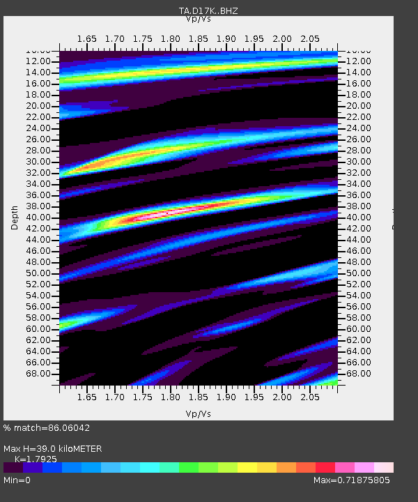
| Estimated Moho Depth: |
39.0 km |
| Estimated Crust Vp/Vs: |
1.79 |
| Assumed Crust Vp: |
6.276 km/s |
| Estimated Crust Vs: |
3.501 km/s |
| Estimated Crust Poisson's Ratio: |
0.27 |
|
| Radial Match: |
86.06042 % |
| Radial Bump: |
386 |
| Transverse Match: |
89.17655 % |
| Transverse Bump: |
399 |
| SOD ConfigId: |
13570011 |
| Insert Time: |
2019-04-30 17:22:45.687 +0000 |
| GWidth: |
2.5 |
| Max Bumps: |
400 |
| Tol: |
0.001 |
|

Signal To Noise
| Channel | StoN | STA | LTA |
| TA:D17K: :BHZ:20180805T11:59:21.625002Z | 7.438624 | 7.14175E-7 | 9.600902E-8 |
| TA:D17K: :BHN:20180805T11:59:21.625002Z | 2.6372275 | 1.877756E-7 | 7.1201896E-8 |
| TA:D17K: :BHE:20180805T11:59:21.625002Z | 2.7407553 | 2.6289473E-7 | 9.592054E-8 |
| Arrivals |
| Ps | 5.0 SECOND |
| PpPs | 17 SECOND |
| PsPs/PpSs | 22 SECOND |


