You are here: Home > Network List > TA - USArray Transportable Network (new EarthScope stations) Stations List
> Station P17K Kvichak River, AK, USA > Earthquake Result Viewer
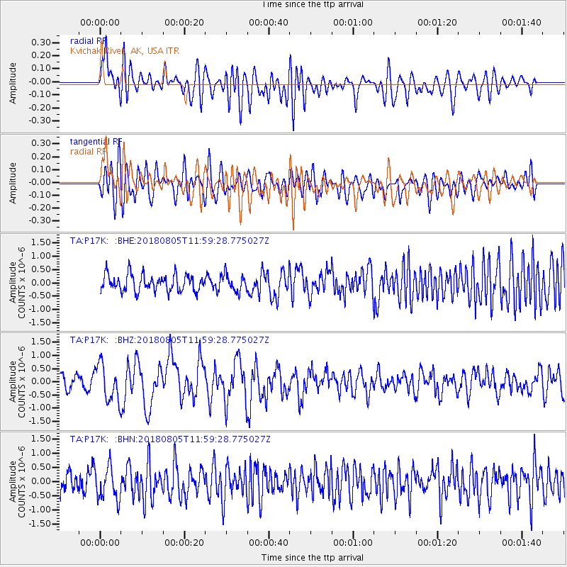
P17K Kvichak River, AK, USA - Earthquake Result Viewer
*The percent match for this event was below the threshold and hence no stack was calculated.
| Earthquake location: |
Sumbawa Region, Indonesia |
| Earthquake latitude/longitude: |
-8.3/116.5 |
| Earthquake time(UTC): |
2018/08/05 (217) 11:46:34 GMT |
| Earthquake Depth: |
10 km |
| Earthquake Magnitude: |
7.0 Mww |
| Earthquake Catalog/Contributor: |
NEIC PDE/us |
|
| Network: |
TA USArray Transportable Network (new EarthScope stations) |
| Station: |
P17K Kvichak River, AK, USA |
| Lat/Lon: |
59.20 N/156.44 W |
| Elevation: |
91 m |
|
| Distance: |
95.6 deg |
| Az: |
31.092 deg |
| Baz: |
263.283 deg |
| Ray Param: |
$rayparam |
*The percent match for this event was below the threshold and hence was not used in the summary stack. |
|
| Radial Match: |
66.66006 % |
| Radial Bump: |
400 |
| Transverse Match: |
60.54236 % |
| Transverse Bump: |
400 |
| SOD ConfigId: |
13570011 |
| Insert Time: |
2019-04-30 17:23:42.477 +0000 |
| GWidth: |
2.5 |
| Max Bumps: |
400 |
| Tol: |
0.001 |
|
Signal To Noise
| Channel | StoN | STA | LTA |
| TA:P17K: :BHZ:20180805T11:59:28.775027Z | 3.0373063 | 7.1092234E-7 | 2.3406344E-7 |
| TA:P17K: :BHN:20180805T11:59:28.775027Z | 1.7016634 | 5.779075E-7 | 3.3961328E-7 |
| TA:P17K: :BHE:20180805T11:59:28.775027Z | 1.0134852 | 3.234511E-7 | 3.1914732E-7 |
| Arrivals |
| Ps | |
| PpPs | |
| PsPs/PpSs | |


