You are here: Home > Network List > TA - USArray Transportable Network (new EarthScope stations) Stations List
> Station E20K Nigu River, AK, USA > Earthquake Result Viewer
E20K Nigu River, AK, USA - Earthquake Result Viewer
| Earthquake location: |
Sumbawa Region, Indonesia |
| Earthquake latitude/longitude: |
-8.4/116.1 |
| Earthquake time(UTC): |
2018/08/05 (217) 12:49:55 GMT |
| Earthquake Depth: |
31 km |
| Earthquake Magnitude: |
5.5 mb |
| Earthquake Catalog/Contributor: |
NEIC PDE/us |
|
| Network: |
TA USArray Transportable Network (new EarthScope stations) |
| Station: |
E20K Nigu River, AK, USA |
| Lat/Lon: |
68.26 N/156.19 W |
| Elevation: |
866 m |
|
| Distance: |
96.8 deg |
| Az: |
22.021 deg |
| Baz: |
264.735 deg |
| Ray Param: |
0.04038087 |
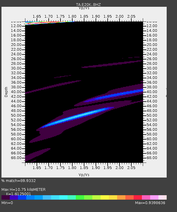
| Estimated Moho Depth: |
10.75 km |
| Estimated Crust Vp/Vs: |
1.61 |
| Assumed Crust Vp: |
6.221 km/s |
| Estimated Crust Vs: |
3.858 km/s |
| Estimated Crust Poisson's Ratio: |
0.19 |
|
| Radial Match: |
89.9332 % |
| Radial Bump: |
400 |
| Transverse Match: |
87.51128 % |
| Transverse Bump: |
400 |
| SOD ConfigId: |
13570011 |
| Insert Time: |
2019-04-30 17:26:07.888 +0000 |
| GWidth: |
2.5 |
| Max Bumps: |
400 |
| Tol: |
0.001 |
|
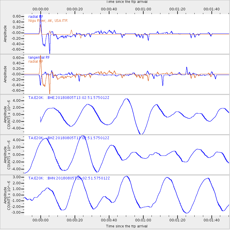
Signal To Noise
| Channel | StoN | STA | LTA |
| TA:E20K: :BHZ:20180805T13:02:51.575012Z | 1.7492565 | 4.7522144E-6 | 2.7167052E-6 |
| TA:E20K: :BHN:20180805T13:02:51.575012Z | 1.0692766 | 9.205921E-7 | 8.609485E-7 |
| TA:E20K: :BHE:20180805T13:02:51.575012Z | 1.0365387 | 1.883939E-6 | 1.8175288E-6 |
| Arrivals |
| Ps | 1.1 SECOND |
| PpPs | 4.4 SECOND |
| PsPs/PpSs | 5.5 SECOND |


