You are here: Home > Network List > AV - Alaska Volcano Observatory Stations List
> Station MAPS Pakushin Southeast, Makushin Volcano, Alaska > Earthquake Result Viewer
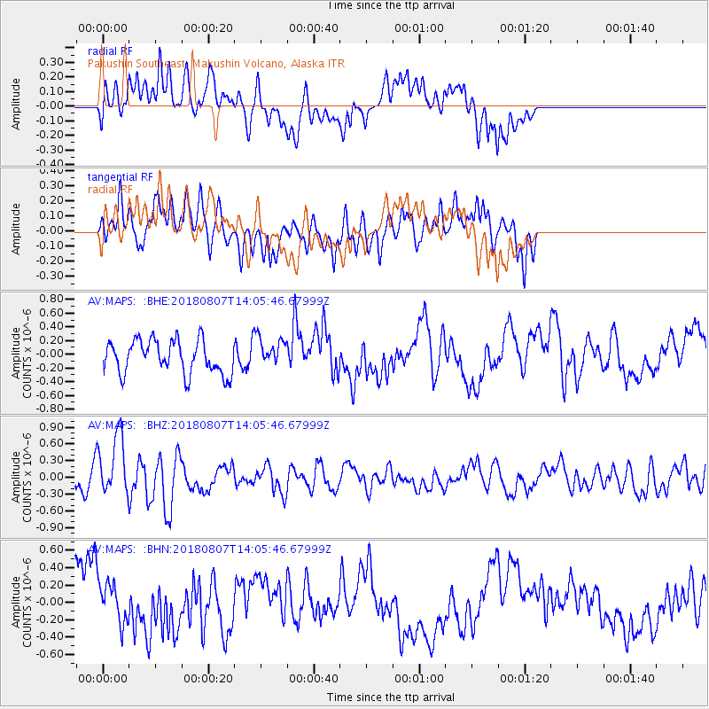
MAPS Pakushin Southeast, Makushin Volcano, Alaska - Earthquake Result Viewer
*The percent match for this event was below the threshold and hence no stack was calculated.
| Earthquake location: |
Greenland Sea |
| Earthquake latitude/longitude: |
74.6/8.4 |
| Earthquake time(UTC): |
2018/08/07 (219) 13:57:09 GMT |
| Earthquake Depth: |
10 km |
| Earthquake Magnitude: |
5.8 Mww |
| Earthquake Catalog/Contributor: |
NEIC PDE/us |
|
| Network: |
AV Alaska Volcano Observatory |
| Station: |
MAPS Pakushin Southeast, Makushin Volcano, Alaska |
| Lat/Lon: |
53.81 N/166.94 W |
| Elevation: |
333 m |
|
| Distance: |
51.8 deg |
| Az: |
356.483 deg |
| Baz: |
1.581 deg |
| Ray Param: |
$rayparam |
*The percent match for this event was below the threshold and hence was not used in the summary stack. |
|
| Radial Match: |
63.006004 % |
| Radial Bump: |
400 |
| Transverse Match: |
45.63725 % |
| Transverse Bump: |
400 |
| SOD ConfigId: |
13570011 |
| Insert Time: |
2019-04-30 17:28:51.485 +0000 |
| GWidth: |
2.5 |
| Max Bumps: |
400 |
| Tol: |
0.001 |
|
Signal To Noise
| Channel | StoN | STA | LTA |
| AV:MAPS: :BHZ:20180807T14:05:46.67999Z | 3.058429 | 5.524994E-7 | 1.8064809E-7 |
| AV:MAPS: :BHN:20180807T14:05:46.67999Z | 0.82388526 | 2.3754357E-7 | 2.883212E-7 |
| AV:MAPS: :BHE:20180807T14:05:46.67999Z | 0.7977429 | 1.9374274E-7 | 2.4286362E-7 |
| Arrivals |
| Ps | |
| PpPs | |
| PsPs/PpSs | |


