You are here: Home > Network List > AV - Alaska Volcano Observatory Stations List
> Station SPWE Spurr West, Mount Spurr, Alaska > Earthquake Result Viewer
SPWE Spurr West, Mount Spurr, Alaska - Earthquake Result Viewer
| Earthquake location: |
Greenland Sea |
| Earthquake latitude/longitude: |
74.6/8.4 |
| Earthquake time(UTC): |
2018/08/07 (219) 13:57:09 GMT |
| Earthquake Depth: |
10 km |
| Earthquake Magnitude: |
5.8 Mww |
| Earthquake Catalog/Contributor: |
NEIC PDE/us |
|
| Network: |
AV Alaska Volcano Observatory |
| Station: |
SPWE Spurr West, Mount Spurr, Alaska |
| Lat/Lon: |
61.27 N/152.56 W |
| Elevation: |
1317 m |
|
| Distance: |
43.8 deg |
| Az: |
346.829 deg |
| Baz: |
7.226 deg |
| Ray Param: |
0.0723337 |
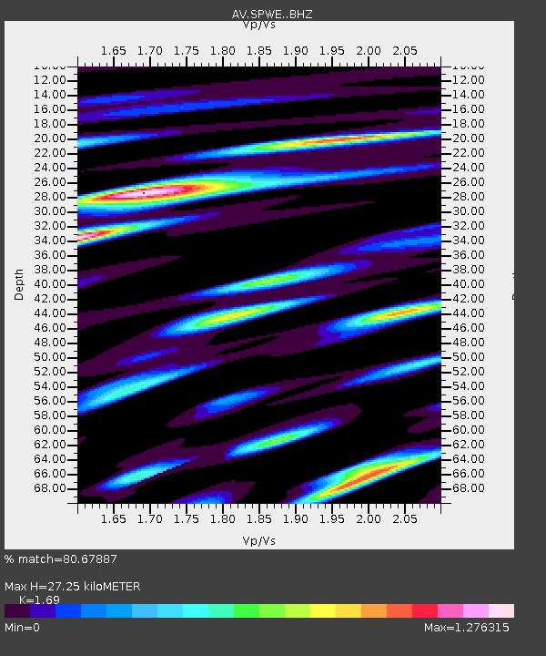
| Estimated Moho Depth: |
27.25 km |
| Estimated Crust Vp/Vs: |
1.69 |
| Assumed Crust Vp: |
6.566 km/s |
| Estimated Crust Vs: |
3.885 km/s |
| Estimated Crust Poisson's Ratio: |
0.23 |
|
| Radial Match: |
80.67887 % |
| Radial Bump: |
400 |
| Transverse Match: |
75.101524 % |
| Transverse Bump: |
400 |
| SOD ConfigId: |
13570011 |
| Insert Time: |
2019-04-30 17:29:01.983 +0000 |
| GWidth: |
2.5 |
| Max Bumps: |
400 |
| Tol: |
0.001 |
|

Signal To Noise
| Channel | StoN | STA | LTA |
| AV:SPWE: :BHZ:20180807T14:04:44.519987Z | 7.222417 | 3.4825177E-7 | 4.821818E-8 |
| AV:SPWE: :BHN:20180807T14:04:44.519987Z | 2.259679 | 1.8089585E-7 | 8.005378E-8 |
| AV:SPWE: :BHE:20180807T14:04:44.519987Z | 1.0539511 | 5.7621307E-8 | 5.4671705E-8 |
| Arrivals |
| Ps | 3.1 SECOND |
| PpPs | 10 SECOND |
| PsPs/PpSs | 13 SECOND |


