You are here: Home > Network List > CI - Caltech Regional Seismic Network Stations List
> Station MPP McPhearson Peak > Earthquake Result Viewer
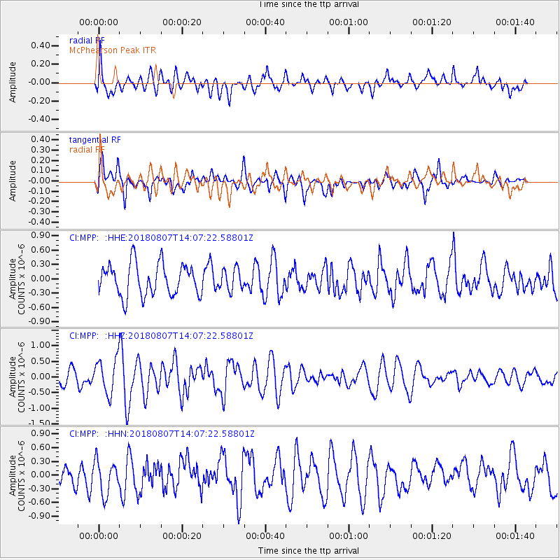
MPP McPhearson Peak - Earthquake Result Viewer
*The percent match for this event was below the threshold and hence no stack was calculated.
| Earthquake location: |
Greenland Sea |
| Earthquake latitude/longitude: |
74.6/8.4 |
| Earthquake time(UTC): |
2018/08/07 (219) 13:57:09 GMT |
| Earthquake Depth: |
10 km |
| Earthquake Magnitude: |
5.8 Mww |
| Earthquake Catalog/Contributor: |
NEIC PDE/us |
|
| Network: |
CI Caltech Regional Seismic Network |
| Station: |
MPP McPhearson Peak |
| Lat/Lon: |
34.89 N/119.81 W |
| Elevation: |
1739 m |
|
| Distance: |
65.6 deg |
| Az: |
314.821 deg |
| Baz: |
13.303 deg |
| Ray Param: |
$rayparam |
*The percent match for this event was below the threshold and hence was not used in the summary stack. |
|
| Radial Match: |
64.402565 % |
| Radial Bump: |
400 |
| Transverse Match: |
65.76828 % |
| Transverse Bump: |
400 |
| SOD ConfigId: |
13570011 |
| Insert Time: |
2019-04-30 17:30:15.572 +0000 |
| GWidth: |
2.5 |
| Max Bumps: |
400 |
| Tol: |
0.001 |
|
Signal To Noise
| Channel | StoN | STA | LTA |
| CI:MPP: :HHZ:20180807T14:07:22.58801Z | 2.5186298 | 5.7219347E-7 | 2.2718443E-7 |
| CI:MPP: :HHN:20180807T14:07:22.58801Z | 1.6848283 | 3.7087526E-7 | 2.2012645E-7 |
| CI:MPP: :HHE:20180807T14:07:22.58801Z | 0.6887572 | 2.2845514E-7 | 3.3169187E-7 |
| Arrivals |
| Ps | |
| PpPs | |
| PsPs/PpSs | |


