You are here: Home > Network List > CN - Canadian National Seismograph Network Stations List
> Station A21 St-Andre, QC, CA > Earthquake Result Viewer
A21 St-Andre, QC, CA - Earthquake Result Viewer
| Earthquake location: |
Greenland Sea |
| Earthquake latitude/longitude: |
74.6/8.4 |
| Earthquake time(UTC): |
2018/08/07 (219) 13:57:09 GMT |
| Earthquake Depth: |
10 km |
| Earthquake Magnitude: |
5.8 Mww |
| Earthquake Catalog/Contributor: |
NEIC PDE/us |
|
| Network: |
CN Canadian National Seismograph Network |
| Station: |
A21 St-Andre, QC, CA |
| Lat/Lon: |
47.70 N/69.69 W |
| Elevation: |
47 m |
|
| Distance: |
41.6 deg |
| Az: |
275.382 deg |
| Baz: |
23.146 deg |
| Ray Param: |
0.073696196 |
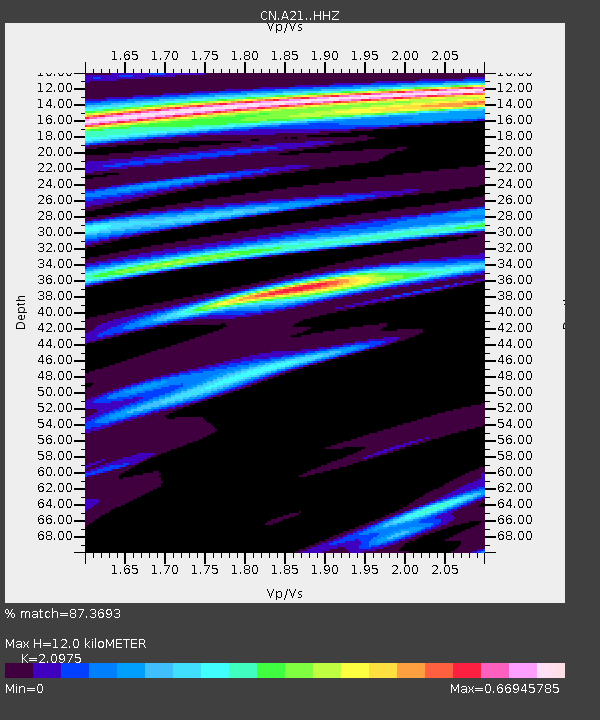
| Estimated Moho Depth: |
12.0 km |
| Estimated Crust Vp/Vs: |
2.10 |
| Assumed Crust Vp: |
6.419 km/s |
| Estimated Crust Vs: |
3.06 km/s |
| Estimated Crust Poisson's Ratio: |
0.35 |
|
| Radial Match: |
87.3693 % |
| Radial Bump: |
244 |
| Transverse Match: |
63.812233 % |
| Transverse Bump: |
400 |
| SOD ConfigId: |
13570011 |
| Insert Time: |
2019-04-30 17:30:34.714 +0000 |
| GWidth: |
2.5 |
| Max Bumps: |
400 |
| Tol: |
0.001 |
|

Signal To Noise
| Channel | StoN | STA | LTA |
| CN:A21: :HHZ:20180807T14:04:27.010007Z | 5.95622 | 6.859074E-7 | 1.1515818E-7 |
| CN:A21: :HHN:20180807T14:04:27.010007Z | 3.1162908 | 3.9079507E-7 | 1.2540391E-7 |
| CN:A21: :HHE:20180807T14:04:27.010007Z | 1.9445934 | 2.1676989E-7 | 1.1147312E-7 |
| Arrivals |
| Ps | 2.2 SECOND |
| PpPs | 5.5 SECOND |
| PsPs/PpSs | 7.6 SECOND |


