You are here: Home > Network List > LD - Lamont-Doherty Cooperative Seismographic Network Stations List
> Station BMNY Brushton-Moira, New York > Earthquake Result Viewer
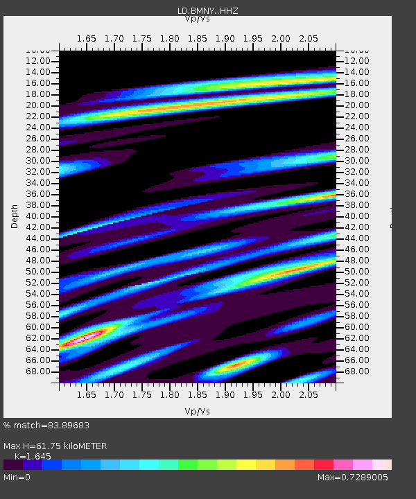
BMNY Brushton-Moira, New York - Earthquake Result Viewer
| Earthquake location: |
Greenland Sea |
| Earthquake latitude/longitude: |
74.6/8.4 |
| Earthquake time(UTC): |
2018/08/07 (219) 13:57:09 GMT |
| Earthquake Depth: |
10 km |
| Earthquake Magnitude: |
5.8 Mww |
| Earthquake Catalog/Contributor: |
NEIC PDE/us |
|
| Network: |
LD Lamont-Doherty Cooperative Seismographic Network |
| Station: |
BMNY Brushton-Moira, New York |
| Lat/Lon: |
44.84 N/74.51 W |
| Elevation: |
115 m |
|
| Distance: |
45.5 deg |
| Az: |
278.275 deg |
| Baz: |
21.773 deg |
| Ray Param: |
0.07122796 |
| Estimated Moho Depth: |
61.75 km |
| Estimated Crust Vp/Vs: |
1.64 |
| Assumed Crust Vp: |
6.419 km/s |
| Estimated Crust Vs: |
3.902 km/s |
| Estimated Crust Poisson's Ratio: |
0.21 |
|
| Radial Match: |
83.89683 % |
| Radial Bump: |
321 |
| Transverse Match: |
55.453365 % |
| Transverse Bump: |
400 |
| SOD ConfigId: |
13570011 |
| Insert Time: |
2019-04-30 17:32:36.952 +0000 |
| GWidth: |
2.5 |
| Max Bumps: |
400 |
| Tol: |
0.001 |
|

Signal To Noise
| Channel | StoN | STA | LTA |
| LD:BMNY: :HHZ:20180807T14:04:58.570005Z | 3.8014712 | 4.6172246E-7 | 1.2145888E-7 |
| LD:BMNY: :HHN:20180807T14:04:58.570005Z | 2.3176153 | 2.2849754E-7 | 9.859166E-8 |
| LD:BMNY: :HHE:20180807T14:04:58.570005Z | 2.1193926 | 1.3912647E-7 | 6.564449E-8 |
| Arrivals |
| Ps | 6.6 SECOND |
| PpPs | 24 SECOND |
| PsPs/PpSs | 30 SECOND |


