You are here: Home > Network List > CI - Caltech Regional Seismic Network Stations List
> Station PHL Parkhill, California, USA > Earthquake Result Viewer
PHL Parkhill, California, USA - Earthquake Result Viewer
| Earthquake location: |
E. Russia-N.E. China Border Reg. |
| Earthquake latitude/longitude: |
43.8/130.7 |
| Earthquake time(UTC): |
2002/06/28 (179) 17:19:30 GMT |
| Earthquake Depth: |
566 km |
| Earthquake Magnitude: |
6.7 MB, 7.3 MW, 7.3 MW |
| Earthquake Catalog/Contributor: |
WHDF/NEIC |
|
| Network: |
CI Caltech Regional Seismic Network |
| Station: |
PHL Parkhill, California, USA |
| Lat/Lon: |
35.41 N/120.55 W |
| Elevation: |
351 m |
|
| Distance: |
78.1 deg |
| Az: |
52.227 deg |
| Baz: |
315.476 deg |
| Ray Param: |
0.048141323 |
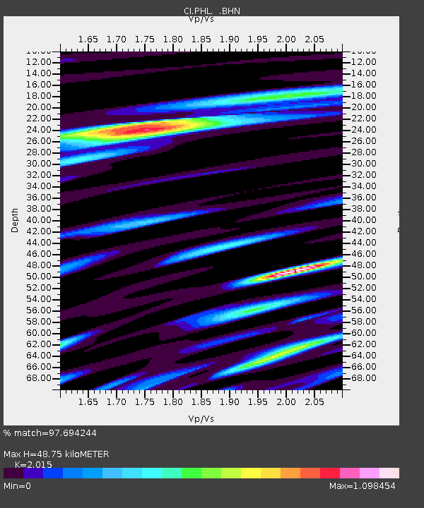
| Estimated Moho Depth: |
48.75 km |
| Estimated Crust Vp/Vs: |
2.02 |
| Assumed Crust Vp: |
6.183 km/s |
| Estimated Crust Vs: |
3.068 km/s |
| Estimated Crust Poisson's Ratio: |
0.34 |
|
| Radial Match: |
97.694244 % |
| Radial Bump: |
400 |
| Transverse Match: |
92.08022 % |
| Transverse Bump: |
400 |
| SOD ConfigId: |
3787 |
| Insert Time: |
2010-02-26 02:08:03.086 +0000 |
| GWidth: |
2.5 |
| Max Bumps: |
400 |
| Tol: |
0.001 |
|

Signal To Noise
| Channel | StoN | STA | LTA |
| CI:PHL: :BHN:20020628T17:29:59.910015Z | 2.6250434 | 1.4288465E-6 | 5.443135E-7 |
| CI:PHL: :BHE:20020628T17:29:59.910015Z | 2.3296294 | 1.2137806E-6 | 5.2101876E-7 |
| CI:PHL: :BHZ:20020628T17:29:59.910015Z | 12.462925 | 4.534718E-6 | 3.638566E-7 |
| Arrivals |
| Ps | 8.2 SECOND |
| PpPs | 23 SECOND |
| PsPs/PpSs | 31 SECOND |


