You are here: Home > Network List > TA - USArray Transportable Network (new EarthScope stations) Stations List
> Station B16A M & M Farms, Shelby, MT, USA > Earthquake Result Viewer
B16A M & M Farms, Shelby, MT, USA - Earthquake Result Viewer
| Earthquake location: |
Near Coast Of Northern Chile |
| Earthquake latitude/longitude: |
-22.9/-70.2 |
| Earthquake time(UTC): |
2007/11/15 (319) 15:05:58 GMT |
| Earthquake Depth: |
26 km |
| Earthquake Magnitude: |
6.1 MB, 6.6 MS, 6.8 MW, 6.6 MW |
| Earthquake Catalog/Contributor: |
WHDF/NEIC |
|
| Network: |
TA USArray Transportable Network (new EarthScope stations) |
| Station: |
B16A M & M Farms, Shelby, MT, USA |
| Lat/Lon: |
48.41 N/111.71 W |
| Elevation: |
1038 m |
|
| Distance: |
80.1 deg |
| Az: |
333.395 deg |
| Baz: |
141.704 deg |
| Ray Param: |
0.048457164 |
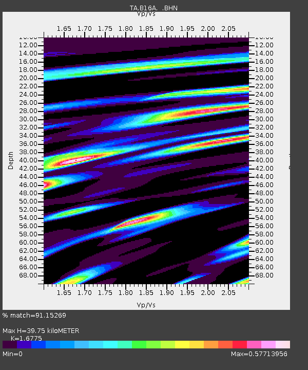
| Estimated Moho Depth: |
39.75 km |
| Estimated Crust Vp/Vs: |
1.68 |
| Assumed Crust Vp: |
6.242 km/s |
| Estimated Crust Vs: |
3.721 km/s |
| Estimated Crust Poisson's Ratio: |
0.22 |
|
| Radial Match: |
91.15269 % |
| Radial Bump: |
400 |
| Transverse Match: |
75.44985 % |
| Transverse Bump: |
400 |
| SOD ConfigId: |
2564 |
| Insert Time: |
2010-03-06 13:25:42.852 +0000 |
| GWidth: |
2.5 |
| Max Bumps: |
400 |
| Tol: |
0.001 |
|

Signal To Noise
| Channel | StoN | STA | LTA |
| TA:B16A: :BHN:20071115T15:17:34.750024Z | 2.466552 | 4.8423067E-7 | 1.9631885E-7 |
| TA:B16A: :BHE:20071115T15:17:34.750024Z | 2.2596588 | 4.3312468E-7 | 1.9167703E-7 |
| TA:B16A: :BHZ:20071115T15:17:34.750024Z | 3.2636929 | 9.10845E-7 | 2.7908416E-7 |
| Arrivals |
| Ps | 4.4 SECOND |
| PpPs | 17 SECOND |
| PsPs/PpSs | 21 SECOND |


