You are here: Home > Network List > MU - Miami University Seismic Network Stations List
> Station MUH1 Harrison > Earthquake Result Viewer
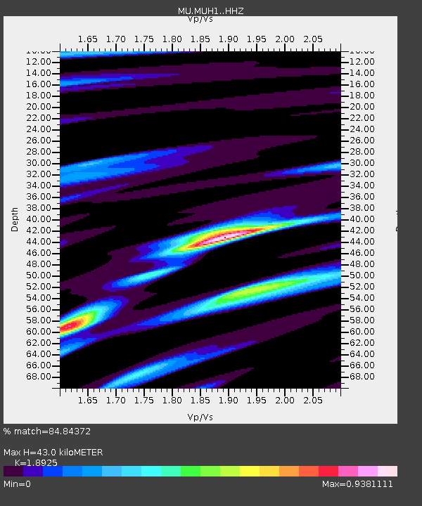
MUH1 Harrison - Earthquake Result Viewer
| Earthquake location: |
Greenland Sea |
| Earthquake latitude/longitude: |
74.6/8.4 |
| Earthquake time(UTC): |
2018/08/07 (219) 13:57:09 GMT |
| Earthquake Depth: |
10 km |
| Earthquake Magnitude: |
5.8 Mww |
| Earthquake Catalog/Contributor: |
NEIC PDE/us |
|
| Network: |
MU Miami University Seismic Network |
| Station: |
MUH1 Harrison |
| Lat/Lon: |
40.23 N/81.15 W |
| Elevation: |
365 m |
|
| Distance: |
51.6 deg |
| Az: |
282.209 deg |
| Baz: |
19.903 deg |
| Ray Param: |
0.06733274 |
| Estimated Moho Depth: |
43.0 km |
| Estimated Crust Vp/Vs: |
1.89 |
| Assumed Crust Vp: |
6.483 km/s |
| Estimated Crust Vs: |
3.425 km/s |
| Estimated Crust Poisson's Ratio: |
0.31 |
|
| Radial Match: |
84.84372 % |
| Radial Bump: |
327 |
| Transverse Match: |
60.944134 % |
| Transverse Bump: |
400 |
| SOD ConfigId: |
13570011 |
| Insert Time: |
2019-04-30 17:33:12.435 +0000 |
| GWidth: |
2.5 |
| Max Bumps: |
400 |
| Tol: |
0.001 |
|

Signal To Noise
| Channel | StoN | STA | LTA |
| MU:MUH1: :HHZ:20180807T14:05:45.065Z | 2.8084714 | 1.4813793E-6 | 5.2746816E-7 |
| MU:MUH1: :HHN:20180807T14:05:45.065Z | 2.0116363 | 9.498158E-7 | 4.7216085E-7 |
| MU:MUH1: :HHE:20180807T14:05:45.065Z | 1.3019705 | 4.7193203E-7 | 3.6247522E-7 |
| Arrivals |
| Ps | 6.2 SECOND |
| PpPs | 18 SECOND |
| PsPs/PpSs | 24 SECOND |


