You are here: Home > Network List > TA - USArray Transportable Network (new EarthScope stations) Stations List
> Station B16A M & M Farms, Shelby, MT, USA > Earthquake Result Viewer
B16A M & M Farms, Shelby, MT, USA - Earthquake Result Viewer
| Earthquake location: |
Volcano Islands, Japan Region |
| Earthquake latitude/longitude: |
22.0/142.7 |
| Earthquake time(UTC): |
2007/09/28 (271) 13:38:59 GMT |
| Earthquake Depth: |
276 km |
| Earthquake Magnitude: |
6.7 MB, 7.4 MW, 7.4 MW |
| Earthquake Catalog/Contributor: |
WHDF/NEIC |
|
| Network: |
TA USArray Transportable Network (new EarthScope stations) |
| Station: |
B16A M & M Farms, Shelby, MT, USA |
| Lat/Lon: |
48.41 N/111.71 W |
| Elevation: |
1038 m |
|
| Distance: |
83.6 deg |
| Az: |
40.209 deg |
| Baz: |
295.944 deg |
| Ray Param: |
0.0453624 |
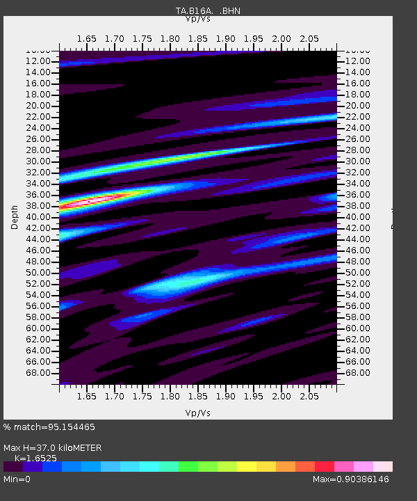
| Estimated Moho Depth: |
37.0 km |
| Estimated Crust Vp/Vs: |
1.65 |
| Assumed Crust Vp: |
6.242 km/s |
| Estimated Crust Vs: |
3.777 km/s |
| Estimated Crust Poisson's Ratio: |
0.21 |
|
| Radial Match: |
95.154465 % |
| Radial Bump: |
400 |
| Transverse Match: |
85.98123 % |
| Transverse Bump: |
400 |
| SOD ConfigId: |
2564 |
| Insert Time: |
2010-03-06 13:25:56.608 +0000 |
| GWidth: |
2.5 |
| Max Bumps: |
400 |
| Tol: |
0.001 |
|

Signal To Noise
| Channel | StoN | STA | LTA |
| TA:B16A: :BHN:20070928T13:50:25.950024Z | 15.447733 | 2.3191278E-6 | 1.5012739E-7 |
| TA:B16A: :BHE:20070928T13:50:25.950024Z | 42.618797 | 5.86684E-6 | 1.376585E-7 |
| TA:B16A: :BHZ:20070928T13:50:25.950024Z | 115.01888 | 1.5150511E-5 | 1.3172195E-7 |
| Arrivals |
| Ps | 4.0 SECOND |
| PpPs | 15 SECOND |
| PsPs/PpSs | 19 SECOND |


