You are here: Home > Network List > N4 - Central and EAstern US Network Stations List
> Station G65A Princeton, ME, USA > Earthquake Result Viewer
G65A Princeton, ME, USA - Earthquake Result Viewer
| Earthquake location: |
Greenland Sea |
| Earthquake latitude/longitude: |
74.6/8.4 |
| Earthquake time(UTC): |
2018/08/07 (219) 13:57:09 GMT |
| Earthquake Depth: |
10 km |
| Earthquake Magnitude: |
5.8 Mww |
| Earthquake Catalog/Contributor: |
NEIC PDE/us |
|
| Network: |
N4 Central and EAstern US Network |
| Station: |
G65A Princeton, ME, USA |
| Lat/Lon: |
45.20 N/67.56 W |
| Elevation: |
78 m |
|
| Distance: |
43.3 deg |
| Az: |
271.944 deg |
| Baz: |
22.146 deg |
| Ray Param: |
0.07261766 |
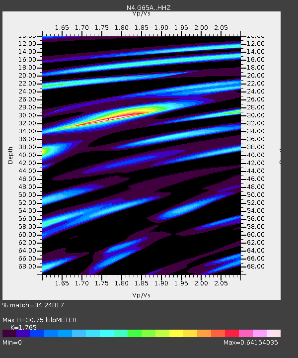
| Estimated Moho Depth: |
30.75 km |
| Estimated Crust Vp/Vs: |
1.76 |
| Assumed Crust Vp: |
6.419 km/s |
| Estimated Crust Vs: |
3.637 km/s |
| Estimated Crust Poisson's Ratio: |
0.26 |
|
| Radial Match: |
84.24817 % |
| Radial Bump: |
212 |
| Transverse Match: |
64.431564 % |
| Transverse Bump: |
400 |
| SOD ConfigId: |
13570011 |
| Insert Time: |
2019-04-30 17:33:34.881 +0000 |
| GWidth: |
2.5 |
| Max Bumps: |
400 |
| Tol: |
0.001 |
|

Signal To Noise
| Channel | StoN | STA | LTA |
| N4:G65A: :HHZ:20180807T14:04:41.20001Z | 6.029542 | 5.7196235E-7 | 9.4860006E-8 |
| N4:G65A: :HHN:20180807T14:04:41.20001Z | 5.0664163 | 3.7676034E-7 | 7.4364266E-8 |
| N4:G65A: :HHE:20180807T14:04:41.20001Z | 1.9195267 | 1.5581303E-7 | 8.117263E-8 |
| Arrivals |
| Ps | 3.9 SECOND |
| PpPs | 12 SECOND |
| PsPs/PpSs | 16 SECOND |


