You are here: Home > Network List > N4 - Central and EAstern US Network Stations List
> Station K30B Basset, NE, USA > Earthquake Result Viewer
K30B Basset, NE, USA - Earthquake Result Viewer
| Earthquake location: |
Greenland Sea |
| Earthquake latitude/longitude: |
74.6/8.4 |
| Earthquake time(UTC): |
2018/08/07 (219) 13:57:09 GMT |
| Earthquake Depth: |
10 km |
| Earthquake Magnitude: |
5.8 Mww |
| Earthquake Catalog/Contributor: |
NEIC PDE/us |
|
| Network: |
N4 Central and EAstern US Network |
| Station: |
K30B Basset, NE, USA |
| Lat/Lon: |
42.67 N/99.61 W |
| Elevation: |
712 m |
|
| Distance: |
53.8 deg |
| Az: |
299.688 deg |
| Baz: |
18.308 deg |
| Ray Param: |
0.065833405 |
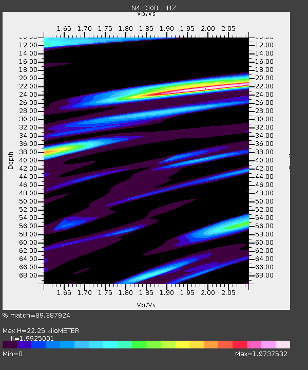
| Estimated Moho Depth: |
22.25 km |
| Estimated Crust Vp/Vs: |
1.99 |
| Assumed Crust Vp: |
6.53 km/s |
| Estimated Crust Vs: |
3.278 km/s |
| Estimated Crust Poisson's Ratio: |
0.33 |
|
| Radial Match: |
89.387924 % |
| Radial Bump: |
389 |
| Transverse Match: |
75.88186 % |
| Transverse Bump: |
400 |
| SOD ConfigId: |
13570011 |
| Insert Time: |
2019-04-30 17:33:47.169 +0000 |
| GWidth: |
2.5 |
| Max Bumps: |
400 |
| Tol: |
0.001 |
|

Signal To Noise
| Channel | StoN | STA | LTA |
| N4:K30B: :HHZ:20180807T14:06:01.799985Z | 6.5327044 | 5.608496E-7 | 8.58526E-8 |
| N4:K30B: :HHN:20180807T14:06:01.799985Z | 2.3870947 | 4.457442E-7 | 1.8673084E-7 |
| N4:K30B: :HHE:20180807T14:06:01.799985Z | 0.97598714 | 1.618275E-7 | 1.6580906E-7 |
| Arrivals |
| Ps | 3.6 SECOND |
| PpPs | 9.7 SECOND |
| PsPs/PpSs | 13 SECOND |


