You are here: Home > Network List > TA - USArray Transportable Network (new EarthScope stations) Stations List
> Station B16A M & M Farms, Shelby, MT, USA > Earthquake Result Viewer
B16A M & M Farms, Shelby, MT, USA - Earthquake Result Viewer

| Earthquake location: |
South Of Mariana Islands |
| Earthquake latitude/longitude: |
12.5/143.2 |
| Earthquake time(UTC): |
2008/05/09 (130) 21:51:29 GMT |
| Earthquake Depth: |
76 km |
| Earthquake Magnitude: |
6.1 MB, 6.7 MW, 6.7 MW |
| Earthquake Catalog/Contributor: |
WHDF/NEIC |
|
| Network: |
TA USArray Transportable Network (new EarthScope stations) |
| Station: |
B16A M & M Farms, Shelby, MT, USA |
| Lat/Lon: |
48.41 N/111.71 W |
| Elevation: |
1038 m |
|
| Distance: |
90.5 deg |
| Az: |
40.034 deg |
| Baz: |
289.471 deg |
| Ray Param: |
0.041653804 |
| Estimated Moho Depth: |
37.5 km |
| Estimated Crust Vp/Vs: |
1.65 |
| Assumed Crust Vp: |
6.242 km/s |
| Estimated Crust Vs: |
3.789 km/s |
| Estimated Crust Poisson's Ratio: |
0.21 |
|
| Radial Match: |
86.98242 % |
| Radial Bump: |
400 |
| Transverse Match: |
71.04208 % |
| Transverse Bump: |
400 |
| SOD ConfigId: |
2504 |
| Insert Time: |
2010-03-06 13:26:46.926 +0000 |
| GWidth: |
2.5 |
| Max Bumps: |
400 |
| Tol: |
0.001 |
|
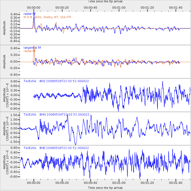
Signal To Noise
| Channel | StoN | STA | LTA |
| TA:B16A: :BHN:20080509T22:03:52.00002Z | 6.3628755 | 5.306327E-7 | 8.339511E-8 |
| TA:B16A: :BHE:20080509T22:03:52.00002Z | 0.6685341 | 7.100709E-8 | 1.0621313E-7 |
| TA:B16A: :BHZ:20080509T22:03:52.00002Z | 2.035402 | 1.7669096E-7 | 8.6808875E-8 |
| Arrivals |
| Ps | 4.0 SECOND |
| PpPs | 16 SECOND |
| PsPs/PpSs | 20 SECOND |


