You are here: Home > Network List > TA - USArray Transportable Network (new EarthScope stations) Stations List
> Station B16A M & M Farms, Shelby, MT, USA > Earthquake Result Viewer
B16A M & M Farms, Shelby, MT, USA - Earthquake Result Viewer
| Earthquake location: |
Iceland |
| Earthquake latitude/longitude: |
64.0/-21.0 |
| Earthquake time(UTC): |
2008/05/29 (150) 15:46:00 GMT |
| Earthquake Depth: |
10 km |
| Earthquake Magnitude: |
6.0 MB, 6.2 MS, 6.3 MW, 6.2 MW |
| Earthquake Catalog/Contributor: |
WHDF/NEIC |
|
| Network: |
TA USArray Transportable Network (new EarthScope stations) |
| Station: |
B16A M & M Farms, Shelby, MT, USA |
| Lat/Lon: |
48.41 N/111.71 W |
| Elevation: |
1038 m |
|
| Distance: |
48.3 deg |
| Az: |
296.757 deg |
| Baz: |
36.201 deg |
| Ray Param: |
0.06947894 |
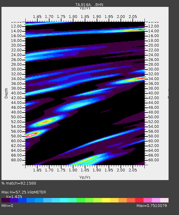
| Estimated Moho Depth: |
57.25 km |
| Estimated Crust Vp/Vs: |
1.62 |
| Assumed Crust Vp: |
6.242 km/s |
| Estimated Crust Vs: |
3.841 km/s |
| Estimated Crust Poisson's Ratio: |
0.20 |
|
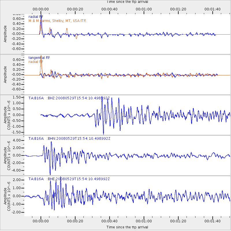
| Radial Match: |
92.1588 % |
| Radial Bump: |
235 |
| Transverse Match: |
79.64349 % |
| Transverse Bump: |
393 |
| SOD ConfigId: |
2504 |
| Insert Time: |
2010-03-06 13:26:48.799 +0000 |
| GWidth: |
2.5 |
| Max Bumps: |
400 |
| Tol: |
0.001 |
|
Signal To Noise
| Channel | StoN | STA | LTA |
| TA:B16A: :BHN:20080529T15:54:10.498992Z | 14.176965 | 1.1647575E-6 | 8.215845E-8 |
| TA:B16A: :BHE:20080529T15:54:10.498992Z | 6.0802646 | 4.754838E-7 | 7.820117E-8 |
| TA:B16A: :BHZ:20080529T15:54:10.498992Z | 5.73606 | 3.920922E-7 | 6.835567E-8 |
| Arrivals |
| Ps | 6.1 SECOND |
| PpPs | 23 SECOND |
| PsPs/PpSs | 29 SECOND |


