You are here: Home > Network List > TA - USArray Transportable Network (new EarthScope stations) Stations List
> Station A36M Sachs Harbour, NT, CAN > Earthquake Result Viewer
A36M Sachs Harbour, NT, CAN - Earthquake Result Viewer
*The percent match for this event was below the threshold and hence no stack was calculated.
| Earthquake location: |
Greenland Sea |
| Earthquake latitude/longitude: |
74.6/8.4 |
| Earthquake time(UTC): |
2018/08/07 (219) 13:57:09 GMT |
| Earthquake Depth: |
10 km |
| Earthquake Magnitude: |
5.8 Mww |
| Earthquake Catalog/Contributor: |
NEIC PDE/us |
|
| Network: |
TA USArray Transportable Network (new EarthScope stations) |
| Station: |
A36M Sachs Harbour, NT, CAN |
| Lat/Lon: |
71.99 N/125.25 W |
| Elevation: |
32 m |
|
| Distance: |
30.8 deg |
| Az: |
333.94 deg |
| Baz: |
22.12 deg |
| Ray Param: |
$rayparam |
*The percent match for this event was below the threshold and hence was not used in the summary stack. |
|
| Radial Match: |
72.452614 % |
| Radial Bump: |
400 |
| Transverse Match: |
68.376884 % |
| Transverse Bump: |
400 |
| SOD ConfigId: |
13570011 |
| Insert Time: |
2019-04-30 17:37:03.808 +0000 |
| GWidth: |
2.5 |
| Max Bumps: |
400 |
| Tol: |
0.001 |
|
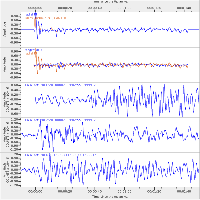
Signal To Noise
| Channel | StoN | STA | LTA |
| TA:A36M: :BHZ:20180807T14:02:55.149991Z | 4.4556174 | 5.382917E-7 | 1.2081192E-7 |
| TA:A36M: :BHN:20180807T14:02:55.149991Z | 3.0947847 | 4.0118064E-7 | 1.2963119E-7 |
| TA:A36M: :BHE:20180807T14:02:55.149991Z | 0.4237097 | 4.977474E-8 | 1.1747369E-7 |
| Arrivals |
| Ps | |
| PpPs | |
| PsPs/PpSs | |


