You are here: Home > Network List > TA - USArray Transportable Network (new EarthScope stations) Stations List
> Station B18K Kokolik River, AK, USA > Earthquake Result Viewer
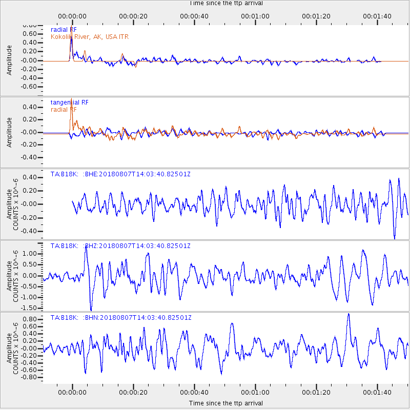
B18K Kokolik River, AK, USA - Earthquake Result Viewer
*The percent match for this event was below the threshold and hence no stack was calculated.
| Earthquake location: |
Greenland Sea |
| Earthquake latitude/longitude: |
74.6/8.4 |
| Earthquake time(UTC): |
2018/08/07 (219) 13:57:09 GMT |
| Earthquake Depth: |
10 km |
| Earthquake Magnitude: |
5.8 Mww |
| Earthquake Catalog/Contributor: |
NEIC PDE/us |
|
| Network: |
TA USArray Transportable Network (new EarthScope stations) |
| Station: |
B18K Kokolik River, AK, USA |
| Lat/Lon: |
69.36 N/161.80 W |
| Elevation: |
222 m |
|
| Distance: |
36.1 deg |
| Az: |
354.12 deg |
| Baz: |
4.42 deg |
| Ray Param: |
$rayparam |
*The percent match for this event was below the threshold and hence was not used in the summary stack. |
|
| Radial Match: |
79.50328 % |
| Radial Bump: |
400 |
| Transverse Match: |
62.726543 % |
| Transverse Bump: |
400 |
| SOD ConfigId: |
13570011 |
| Insert Time: |
2019-04-30 17:37:07.272 +0000 |
| GWidth: |
2.5 |
| Max Bumps: |
400 |
| Tol: |
0.001 |
|
Signal To Noise
| Channel | StoN | STA | LTA |
| TA:B18K: :BHZ:20180807T14:03:40.82501Z | 3.4745605 | 4.851279E-7 | 1.396228E-7 |
| TA:B18K: :BHN:20180807T14:03:40.82501Z | 2.1610234 | 2.4213824E-7 | 1.1204794E-7 |
| TA:B18K: :BHE:20180807T14:03:40.82501Z | 0.74169475 | 6.554926E-8 | 8.8377675E-8 |
| Arrivals |
| Ps | |
| PpPs | |
| PsPs/PpSs | |


