You are here: Home > Network List > TA - USArray Transportable Network (new EarthScope stations) Stations List
> Station E19K Redstone River, AK, USA > Earthquake Result Viewer
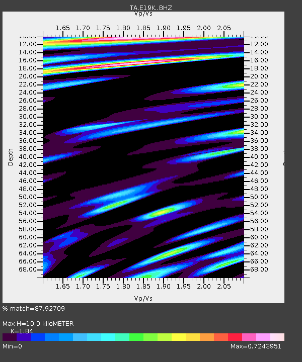
E19K Redstone River, AK, USA - Earthquake Result Viewer
| Earthquake location: |
Greenland Sea |
| Earthquake latitude/longitude: |
74.6/8.4 |
| Earthquake time(UTC): |
2018/08/07 (219) 13:57:09 GMT |
| Earthquake Depth: |
10 km |
| Earthquake Magnitude: |
5.8 Mww |
| Earthquake Catalog/Contributor: |
NEIC PDE/us |
|
| Network: |
TA USArray Transportable Network (new EarthScope stations) |
| Station: |
E19K Redstone River, AK, USA |
| Lat/Lon: |
67.46 N/157.23 W |
| Elevation: |
441 m |
|
| Distance: |
37.8 deg |
| Az: |
351.026 deg |
| Baz: |
6.193 deg |
| Ray Param: |
0.075904496 |
| Estimated Moho Depth: |
10.0 km |
| Estimated Crust Vp/Vs: |
1.84 |
| Assumed Crust Vp: |
6.577 km/s |
| Estimated Crust Vs: |
3.574 km/s |
| Estimated Crust Poisson's Ratio: |
0.29 |
|
| Radial Match: |
87.92709 % |
| Radial Bump: |
399 |
| Transverse Match: |
73.17372 % |
| Transverse Bump: |
400 |
| SOD ConfigId: |
13570011 |
| Insert Time: |
2019-04-30 17:37:27.018 +0000 |
| GWidth: |
2.5 |
| Max Bumps: |
400 |
| Tol: |
0.001 |
|

Signal To Noise
| Channel | StoN | STA | LTA |
| TA:E19K: :BHZ:20180807T14:03:55.70001Z | 6.9359107 | 4.7849676E-7 | 6.898831E-8 |
| TA:E19K: :BHN:20180807T14:03:55.70001Z | 8.157012 | 2.9382576E-7 | 3.602125E-8 |
| TA:E19K: :BHE:20180807T14:03:55.70001Z | 1.4574848 | 5.8693274E-8 | 4.0270248E-8 |
| Arrivals |
| Ps | 1.4 SECOND |
| PpPs | 4.0 SECOND |
| PsPs/PpSs | 5.4 SECOND |


