You are here: Home > Network List > TA - USArray Transportable Network (new EarthScope stations) Stations List
> Station B16A M & M Farms, Shelby, MT, USA > Earthquake Result Viewer
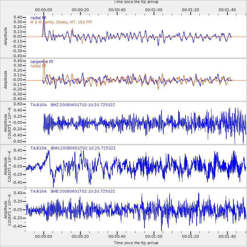
B16A M & M Farms, Shelby, MT, USA - Earthquake Result Viewer
*The percent match for this event was below the threshold and hence no stack was calculated.
| Earthquake location: |
Philippine Islands Region |
| Earthquake latitude/longitude: |
20.1/121.4 |
| Earthquake time(UTC): |
2008/06/01 (153) 01:57:24 GMT |
| Earthquake Depth: |
35 km |
| Earthquake Magnitude: |
6.0 MB, 6.2 MS, 6.3 MW, 6.2 MW |
| Earthquake Catalog/Contributor: |
WHDF/NEIC |
|
| Network: |
TA USArray Transportable Network (new EarthScope stations) |
| Station: |
B16A M & M Farms, Shelby, MT, USA |
| Lat/Lon: |
48.41 N/111.71 W |
| Elevation: |
1038 m |
|
| Distance: |
97.0 deg |
| Az: |
32.451 deg |
| Baz: |
310.819 deg |
| Ray Param: |
$rayparam |
*The percent match for this event was below the threshold and hence was not used in the summary stack. |
|
| Radial Match: |
68.53845 % |
| Radial Bump: |
400 |
| Transverse Match: |
64.48232 % |
| Transverse Bump: |
400 |
| SOD ConfigId: |
2504 |
| Insert Time: |
2010-03-06 13:27:28.492 +0000 |
| GWidth: |
2.5 |
| Max Bumps: |
400 |
| Tol: |
0.001 |
|
Signal To Noise
| Channel | StoN | STA | LTA |
| TA:B16A: :BHN:20080601T02:10:20.72502Z | 3.8589792 | 2.0349724E-7 | 5.2733434E-8 |
| TA:B16A: :BHE:20080601T02:10:20.72502Z | 1.1254997 | 1.1312504E-7 | 1.0051094E-7 |
| TA:B16A: :BHZ:20080601T02:10:20.72502Z | 0.84017915 | 1.0357633E-7 | 1.2327887E-7 |
| Arrivals |
| Ps | |
| PpPs | |
| PsPs/PpSs | |


