You are here: Home > Network List > TA - USArray Transportable Network (new EarthScope stations) Stations List
> Station H23K Yukon River, AK, USA > Earthquake Result Viewer
H23K Yukon River, AK, USA - Earthquake Result Viewer
| Earthquake location: |
Greenland Sea |
| Earthquake latitude/longitude: |
74.6/8.4 |
| Earthquake time(UTC): |
2018/08/07 (219) 13:57:09 GMT |
| Earthquake Depth: |
10 km |
| Earthquake Magnitude: |
5.8 Mww |
| Earthquake Catalog/Contributor: |
NEIC PDE/us |
|
| Network: |
TA USArray Transportable Network (new EarthScope stations) |
| Station: |
H23K Yukon River, AK, USA |
| Lat/Lon: |
65.83 N/149.54 W |
| Elevation: |
617 m |
|
| Distance: |
39.1 deg |
| Az: |
345.791 deg |
| Baz: |
9.146 deg |
| Ray Param: |
0.0752027 |
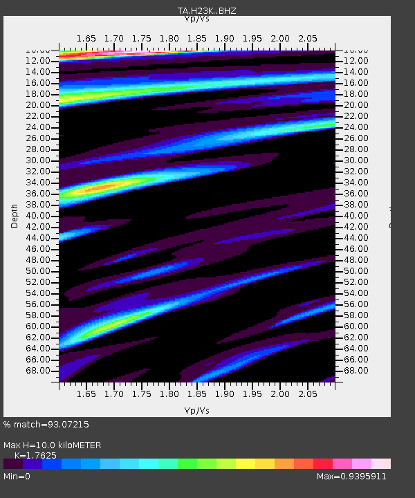
| Estimated Moho Depth: |
10.0 km |
| Estimated Crust Vp/Vs: |
1.76 |
| Assumed Crust Vp: |
6.566 km/s |
| Estimated Crust Vs: |
3.725 km/s |
| Estimated Crust Poisson's Ratio: |
0.26 |
|
| Radial Match: |
93.07215 % |
| Radial Bump: |
400 |
| Transverse Match: |
85.14598 % |
| Transverse Bump: |
400 |
| SOD ConfigId: |
13570011 |
| Insert Time: |
2019-04-30 17:38:00.812 +0000 |
| GWidth: |
2.5 |
| Max Bumps: |
400 |
| Tol: |
0.001 |
|

Signal To Noise
| Channel | StoN | STA | LTA |
| TA:H23K: :BHZ:20180807T14:04:05.899991Z | 8.214695 | 4.414269E-7 | 5.3736247E-8 |
| TA:H23K: :BHN:20180807T14:04:05.899991Z | 3.7546167 | 2.2315155E-7 | 5.943391E-8 |
| TA:H23K: :BHE:20180807T14:04:05.899991Z | 1.6089077 | 6.579627E-8 | 4.0894996E-8 |
| Arrivals |
| Ps | 1.3 SECOND |
| PpPs | 3.9 SECOND |
| PsPs/PpSs | 5.2 SECOND |


