You are here: Home > Network List > TA - USArray Transportable Network (new EarthScope stations) Stations List
> Station I30M Mount Dempster, Yukon, CAN > Earthquake Result Viewer
I30M Mount Dempster, Yukon, CAN - Earthquake Result Viewer
| Earthquake location: |
Greenland Sea |
| Earthquake latitude/longitude: |
74.6/8.4 |
| Earthquake time(UTC): |
2018/08/07 (219) 13:57:09 GMT |
| Earthquake Depth: |
10 km |
| Earthquake Magnitude: |
5.8 Mww |
| Earthquake Catalog/Contributor: |
NEIC PDE/us |
|
| Network: |
TA USArray Transportable Network (new EarthScope stations) |
| Station: |
I30M Mount Dempster, Yukon, CAN |
| Lat/Lon: |
65.22 N/136.38 W |
| Elevation: |
1399 m |
|
| Distance: |
38.5 deg |
| Az: |
337.034 deg |
| Baz: |
14.294 deg |
| Ray Param: |
0.07550573 |
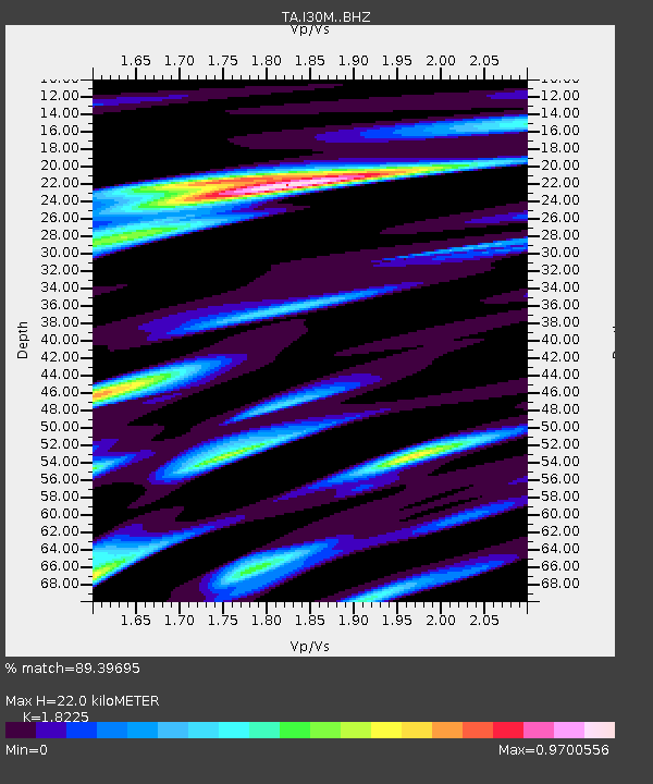
| Estimated Moho Depth: |
22.0 km |
| Estimated Crust Vp/Vs: |
1.82 |
| Assumed Crust Vp: |
6.566 km/s |
| Estimated Crust Vs: |
3.603 km/s |
| Estimated Crust Poisson's Ratio: |
0.28 |
|
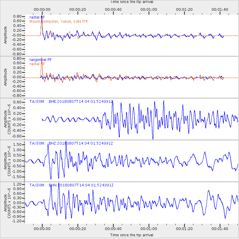
| Radial Match: |
89.39695 % |
| Radial Bump: |
387 |
| Transverse Match: |
75.57976 % |
| Transverse Bump: |
400 |
| SOD ConfigId: |
13570011 |
| Insert Time: |
2019-04-30 17:38:10.943 +0000 |
| GWidth: |
2.5 |
| Max Bumps: |
400 |
| Tol: |
0.001 |
|
Signal To Noise
| Channel | StoN | STA | LTA |
| TA:I30M: :BHZ:20180807T14:04:01.524991Z | 13.632116 | 7.140291E-7 | 5.237845E-8 |
| TA:I30M: :BHN:20180807T14:04:01.524991Z | 5.887455 | 3.9864423E-7 | 6.771079E-8 |
| TA:I30M: :BHE:20180807T14:04:01.524991Z | 2.3361876 | 1.2498224E-7 | 5.3498372E-8 |
| Arrivals |
| Ps | 3.0 SECOND |
| PpPs | 8.8 SECOND |
| PsPs/PpSs | 12 SECOND |


