You are here: Home > Network List > TA - USArray Transportable Network (new EarthScope stations) Stations List
> Station J30M Hart River, Yukon, CAN > Earthquake Result Viewer
J30M Hart River, Yukon, CAN - Earthquake Result Viewer
| Earthquake location: |
Greenland Sea |
| Earthquake latitude/longitude: |
74.6/8.4 |
| Earthquake time(UTC): |
2018/08/07 (219) 13:57:09 GMT |
| Earthquake Depth: |
10 km |
| Earthquake Magnitude: |
5.8 Mww |
| Earthquake Catalog/Contributor: |
NEIC PDE/us |
|
| Network: |
TA USArray Transportable Network (new EarthScope stations) |
| Station: |
J30M Hart River, Yukon, CAN |
| Lat/Lon: |
64.58 N/136.33 W |
| Elevation: |
1419 m |
|
| Distance: |
39.2 deg |
| Az: |
336.749 deg |
| Baz: |
14.114 deg |
| Ray Param: |
0.075144574 |
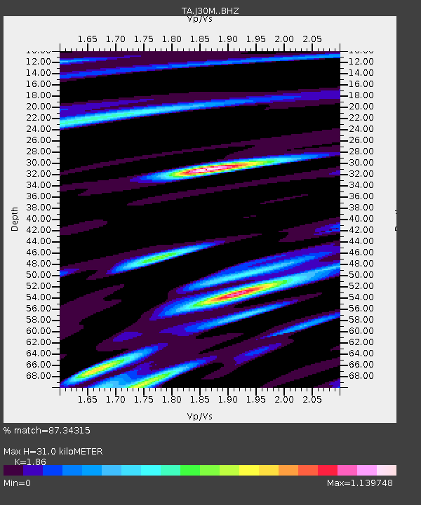
| Estimated Moho Depth: |
31.0 km |
| Estimated Crust Vp/Vs: |
1.86 |
| Assumed Crust Vp: |
6.566 km/s |
| Estimated Crust Vs: |
3.53 km/s |
| Estimated Crust Poisson's Ratio: |
0.30 |
|
| Radial Match: |
87.34315 % |
| Radial Bump: |
400 |
| Transverse Match: |
79.47916 % |
| Transverse Bump: |
400 |
| SOD ConfigId: |
13570011 |
| Insert Time: |
2019-04-30 17:38:18.984 +0000 |
| GWidth: |
2.5 |
| Max Bumps: |
400 |
| Tol: |
0.001 |
|

Signal To Noise
| Channel | StoN | STA | LTA |
| TA:J30M: :BHZ:20180807T14:04:06.749998Z | 9.390111 | 5.995948E-7 | 6.385386E-8 |
| TA:J30M: :BHN:20180807T14:04:06.749998Z | 4.241234 | 4.050371E-7 | 9.549983E-8 |
| TA:J30M: :BHE:20180807T14:04:06.749998Z | 2.4644995 | 1.3353115E-7 | 5.4181854E-8 |
| Arrivals |
| Ps | 4.4 SECOND |
| PpPs | 13 SECOND |
| PsPs/PpSs | 17 SECOND |


