You are here: Home > Network List > IW - Intermountain West Stations List
> Station MOOW Moose Ponds, Wyoming, USA > Earthquake Result Viewer
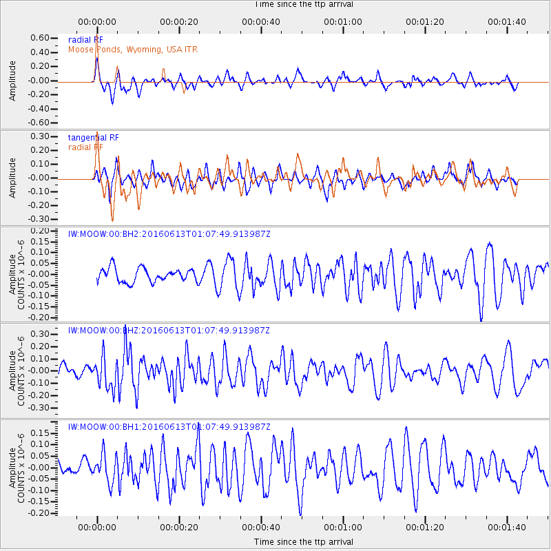
MOOW Moose Ponds, Wyoming, USA - Earthquake Result Viewer
*The percent match for this event was below the threshold and hence no stack was calculated.
| Earthquake location: |
Central East Pacific Rise |
| Earthquake latitude/longitude: |
-4.4/-104.8 |
| Earthquake time(UTC): |
2016/06/13 (165) 00:59:39 GMT |
| Earthquake Depth: |
10 km |
| Earthquake Magnitude: |
5.7 MWW, 5.6 MWB, 5.7 MWC |
| Earthquake Catalog/Contributor: |
NEIC PDE/NEIC COMCAT |
|
| Network: |
IW Intermountain West |
| Station: |
MOOW Moose Ponds, Wyoming, USA |
| Lat/Lon: |
43.75 N/110.74 W |
| Elevation: |
2128 m |
|
| Distance: |
48.3 deg |
| Az: |
354.237 deg |
| Baz: |
172.059 deg |
| Ray Param: |
$rayparam |
*The percent match for this event was below the threshold and hence was not used in the summary stack. |
|
| Radial Match: |
74.218735 % |
| Radial Bump: |
400 |
| Transverse Match: |
58.34563 % |
| Transverse Bump: |
400 |
| SOD ConfigId: |
1609551 |
| Insert Time: |
2016-06-27 01:01:54.579 +0000 |
| GWidth: |
2.5 |
| Max Bumps: |
400 |
| Tol: |
0.001 |
|
Signal To Noise
| Channel | StoN | STA | LTA |
| IW:MOOW:00:BHZ:20160613T01:07:49.913987Z | 2.596244 | 1.268344E-7 | 4.8853032E-8 |
| IW:MOOW:00:BH1:20160613T01:07:49.913987Z | 2.0785947 | 6.2478016E-8 | 3.0057816E-8 |
| IW:MOOW:00:BH2:20160613T01:07:49.913987Z | 2.3825133 | 7.466798E-8 | 3.1340004E-8 |
| Arrivals |
| Ps | |
| PpPs | |
| PsPs/PpSs | |


