You are here: Home > Network List > TA - USArray Transportable Network (new EarthScope stations) Stations List
> Station M53A WI Miller and Sons, Farmdale, OH, USA > Earthquake Result Viewer
M53A WI Miller and Sons, Farmdale, OH, USA - Earthquake Result Viewer
| Earthquake location: |
Greenland Sea |
| Earthquake latitude/longitude: |
74.6/8.4 |
| Earthquake time(UTC): |
2018/08/07 (219) 13:57:09 GMT |
| Earthquake Depth: |
10 km |
| Earthquake Magnitude: |
5.8 Mww |
| Earthquake Catalog/Contributor: |
NEIC PDE/us |
|
| Network: |
TA USArray Transportable Network (new EarthScope stations) |
| Station: |
M53A WI Miller and Sons, Farmdale, OH, USA |
| Lat/Lon: |
41.44 N/80.68 W |
| Elevation: |
334 m |
|
| Distance: |
50.3 deg |
| Az: |
282.312 deg |
| Baz: |
20.275 deg |
| Ray Param: |
0.068146646 |
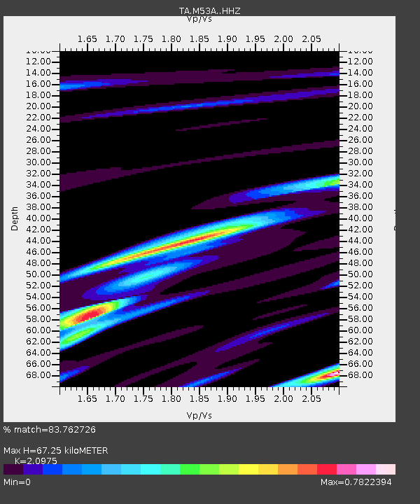
| Estimated Moho Depth: |
67.25 km |
| Estimated Crust Vp/Vs: |
2.10 |
| Assumed Crust Vp: |
6.483 km/s |
| Estimated Crust Vs: |
3.091 km/s |
| Estimated Crust Poisson's Ratio: |
0.35 |
|
| Radial Match: |
83.762726 % |
| Radial Bump: |
382 |
| Transverse Match: |
67.2527 % |
| Transverse Bump: |
400 |
| SOD ConfigId: |
13570011 |
| Insert Time: |
2019-04-30 17:38:49.906 +0000 |
| GWidth: |
2.5 |
| Max Bumps: |
400 |
| Tol: |
0.001 |
|
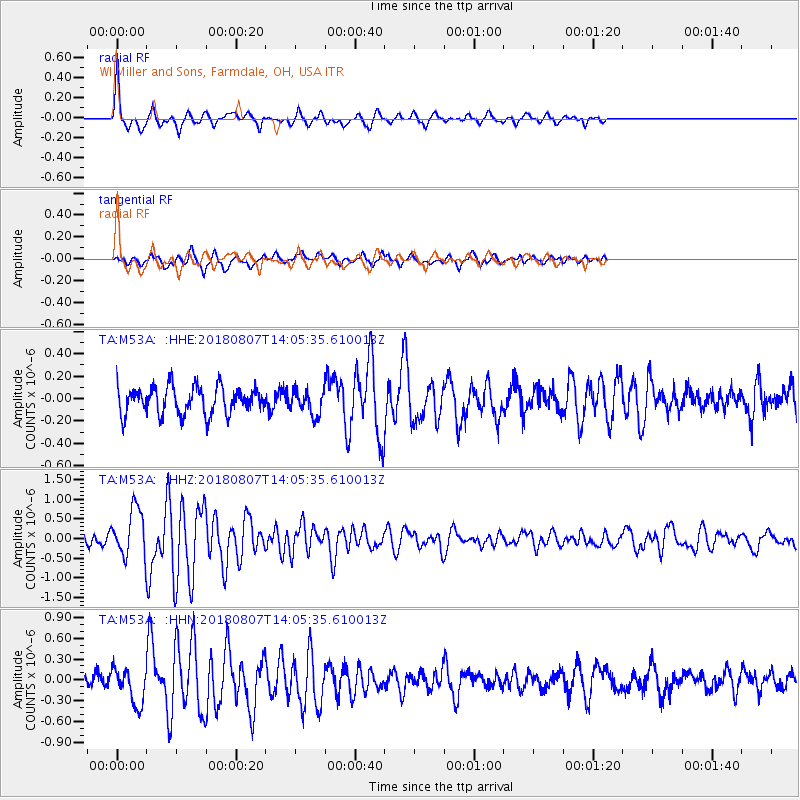
Signal To Noise
| Channel | StoN | STA | LTA |
| TA:M53A: :HHZ:20180807T14:05:35.610013Z | 4.329654 | 6.069814E-7 | 1.4019166E-7 |
| TA:M53A: :HHN:20180807T14:05:35.610013Z | 2.7208123 | 2.5812673E-7 | 9.4871204E-8 |
| TA:M53A: :HHE:20180807T14:05:35.610013Z | 0.87785226 | 1.083875E-7 | 1.2346895E-7 |
| Arrivals |
| Ps | 12 SECOND |
| PpPs | 31 SECOND |
| PsPs/PpSs | 43 SECOND |


