You are here: Home > Network List > TA - USArray Transportable Network (new EarthScope stations) Stations List
> Station N19K Bonanza Creek NPS repeater, AK, USA > Earthquake Result Viewer
N19K Bonanza Creek NPS repeater, AK, USA - Earthquake Result Viewer
| Earthquake location: |
Greenland Sea |
| Earthquake latitude/longitude: |
74.6/8.4 |
| Earthquake time(UTC): |
2018/08/07 (219) 13:57:09 GMT |
| Earthquake Depth: |
10 km |
| Earthquake Magnitude: |
5.8 Mww |
| Earthquake Catalog/Contributor: |
NEIC PDE/us |
|
| Network: |
TA USArray Transportable Network (new EarthScope stations) |
| Station: |
N19K Bonanza Creek NPS repeater, AK, USA |
| Lat/Lon: |
60.81 N/154.48 W |
| Elevation: |
1144 m |
|
| Distance: |
44.3 deg |
| Az: |
348.087 deg |
| Baz: |
6.448 deg |
| Ray Param: |
0.07197416 |
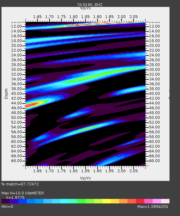
| Estimated Moho Depth: |
10.0 km |
| Estimated Crust Vp/Vs: |
1.98 |
| Assumed Crust Vp: |
6.566 km/s |
| Estimated Crust Vs: |
3.32 km/s |
| Estimated Crust Poisson's Ratio: |
0.33 |
|
| Radial Match: |
87.72472 % |
| Radial Bump: |
400 |
| Transverse Match: |
76.42166 % |
| Transverse Bump: |
400 |
| SOD ConfigId: |
13570011 |
| Insert Time: |
2019-04-30 17:38:55.523 +0000 |
| GWidth: |
2.5 |
| Max Bumps: |
400 |
| Tol: |
0.001 |
|

Signal To Noise
| Channel | StoN | STA | LTA |
| TA:N19K: :BHZ:20180807T14:04:49.100004Z | 8.968445 | 5.736141E-7 | 6.395915E-8 |
| TA:N19K: :BHN:20180807T14:04:49.100004Z | 4.7822814 | 3.5922957E-7 | 7.511678E-8 |
| TA:N19K: :BHE:20180807T14:04:49.100004Z | 2.2730865 | 1.4783811E-7 | 6.5038485E-8 |
| Arrivals |
| Ps | 1.6 SECOND |
| PpPs | 4.3 SECOND |
| PsPs/PpSs | 5.8 SECOND |


