You are here: Home > Network List > TA - USArray Transportable Network (new EarthScope stations) Stations List
> Station O20A White River City, CO, USA > Earthquake Result Viewer
O20A White River City, CO, USA - Earthquake Result Viewer
| Earthquake location: |
Greenland Sea |
| Earthquake latitude/longitude: |
74.6/8.4 |
| Earthquake time(UTC): |
2018/08/07 (219) 13:57:09 GMT |
| Earthquake Depth: |
10 km |
| Earthquake Magnitude: |
5.8 Mww |
| Earthquake Catalog/Contributor: |
NEIC PDE/us |
|
| Network: |
TA USArray Transportable Network (new EarthScope stations) |
| Station: |
O20A White River City, CO, USA |
| Lat/Lon: |
40.13 N/108.24 W |
| Elevation: |
1915 m |
|
| Distance: |
58.2 deg |
| Az: |
306.252 deg |
| Baz: |
16.29 deg |
| Ray Param: |
0.06300777 |
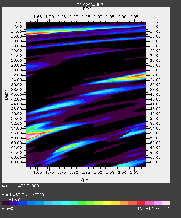
| Estimated Moho Depth: |
57.0 km |
| Estimated Crust Vp/Vs: |
1.63 |
| Assumed Crust Vp: |
6.207 km/s |
| Estimated Crust Vs: |
3.808 km/s |
| Estimated Crust Poisson's Ratio: |
0.20 |
|
| Radial Match: |
80.81008 % |
| Radial Bump: |
379 |
| Transverse Match: |
74.55497 % |
| Transverse Bump: |
400 |
| SOD ConfigId: |
13570011 |
| Insert Time: |
2019-04-30 17:39:05.109 +0000 |
| GWidth: |
2.5 |
| Max Bumps: |
400 |
| Tol: |
0.001 |
|
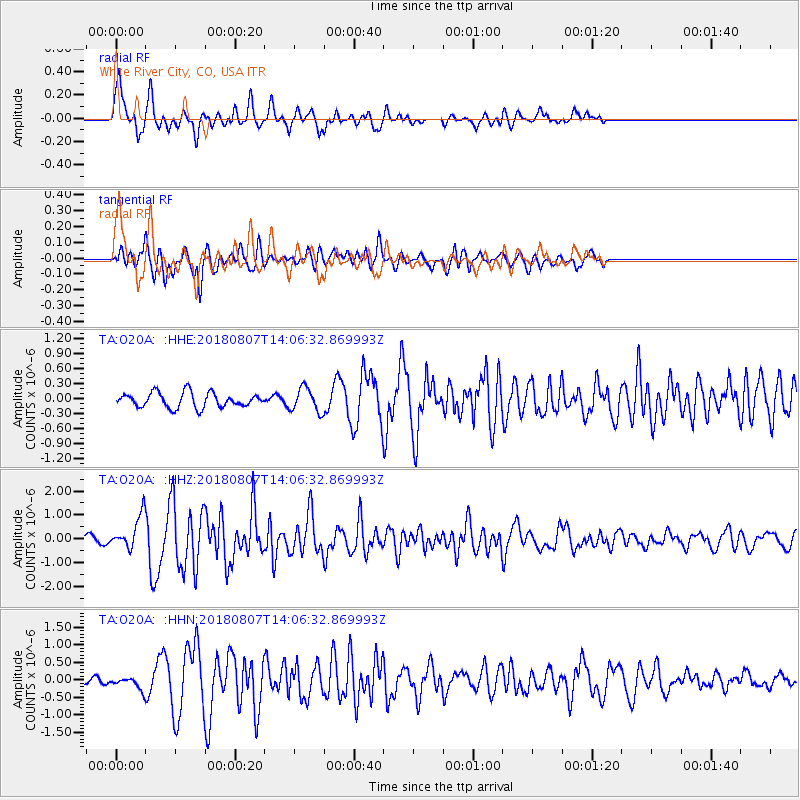
Signal To Noise
| Channel | StoN | STA | LTA |
| TA:O20A: :HHZ:20180807T14:06:32.869993Z | 5.538424 | 7.181435E-7 | 1.2966568E-7 |
| TA:O20A: :HHN:20180807T14:06:32.869993Z | 1.5304384 | 1.9378453E-7 | 1.2662026E-7 |
| TA:O20A: :HHE:20180807T14:06:32.869993Z | 1.6462015 | 2.4200003E-7 | 1.4700511E-7 |
| Arrivals |
| Ps | 6.1 SECOND |
| PpPs | 23 SECOND |
| PsPs/PpSs | 29 SECOND |


