You are here: Home > Network List > TA - USArray Transportable Network (new EarthScope stations) Stations List
> Station B16A M & M Farms, Shelby, MT, USA > Earthquake Result Viewer
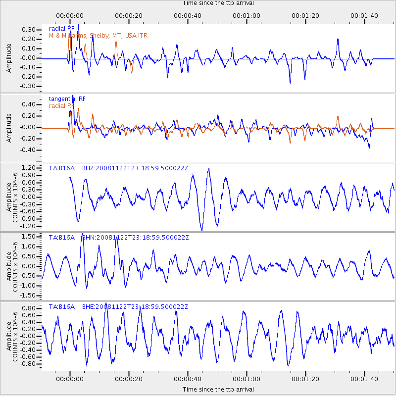
B16A M & M Farms, Shelby, MT, USA - Earthquake Result Viewer
*The percent match for this event was below the threshold and hence no stack was calculated.
| Earthquake location: |
Southeast Of Easter Island |
| Earthquake latitude/longitude: |
-37.2/-95.1 |
| Earthquake time(UTC): |
2008/11/22 (327) 23:06:47 GMT |
| Earthquake Depth: |
10 km |
| Earthquake Magnitude: |
5.6 MB, 5.3 MS, 5.7 MW, 5.7 MW |
| Earthquake Catalog/Contributor: |
WHDF/NEIC |
|
| Network: |
TA USArray Transportable Network (new EarthScope stations) |
| Station: |
B16A M & M Farms, Shelby, MT, USA |
| Lat/Lon: |
48.41 N/111.71 W |
| Elevation: |
1038 m |
|
| Distance: |
86.6 deg |
| Az: |
348.98 deg |
| Baz: |
166.764 deg |
| Ray Param: |
$rayparam |
*The percent match for this event was below the threshold and hence was not used in the summary stack. |
|
| Radial Match: |
70.10895 % |
| Radial Bump: |
400 |
| Transverse Match: |
55.59903 % |
| Transverse Bump: |
400 |
| SOD ConfigId: |
2658 |
| Insert Time: |
2010-03-06 13:28:17.393 +0000 |
| GWidth: |
2.5 |
| Max Bumps: |
400 |
| Tol: |
0.001 |
|
Signal To Noise
| Channel | StoN | STA | LTA |
| TA:B16A: :BHN:20081122T23:18:59.500022Z | 2.2607784 | 7.864503E-7 | 3.4786703E-7 |
| TA:B16A: :BHE:20081122T23:18:59.500022Z | 0.89489365 | 2.439616E-7 | 2.726152E-7 |
| TA:B16A: :BHZ:20081122T23:18:59.500022Z | 0.73153985 | 2.679722E-7 | 3.6631255E-7 |
| Arrivals |
| Ps | |
| PpPs | |
| PsPs/PpSs | |


