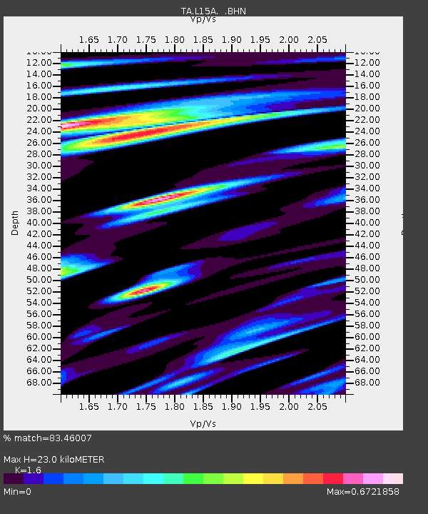
L15A Malad City, ID, USA - Earthquake Result Viewer
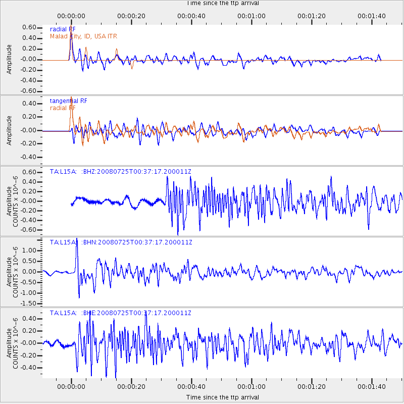
Earthquake location: Rat Islands, Aleutian Islands
Earthquake latitude/longitude: 51.3/179.0
Earthquake time(UTC): 2008/07/25 (207) 00:29:22 GMT
Earthquake Depth: 21 km
Earthquake Magnitude: 5.7 MB, 5.5 MS, 5.9 MW, 5.9 MW
Earthquake Catalog/Contributor: WHDF/NEIC
Network: TA USArray Transportable Network (new EarthScope stations)
Station: L15A Malad City, ID, USA
Lat/Lon: 42.00 N/112.39 W
Elevation: 1646 m
Distance: 46.4 deg
Az: 73.361 deg
Baz: 306.156 deg
Ray Param: 0.07062671
Estimated Moho Depth: 23.0 km
Estimated Crust Vp/Vs: 1.60
Assumed Crust Vp: 6.279 km/s
Estimated Crust Vs: 3.924 km/s
Estimated Crust Poisson's Ratio: 0.18
Radial Match: 83.46007 %
Radial Bump: 400
Transverse Match: 78.88705 %
Transverse Bump: 400
SOD ConfigId: 2504
Insert Time: 2010-03-06 13:29:43.274 +0000
GWidth: 2.5
Max Bumps: 400
Tol: 0.001

Signal To Noise

ChannelStoNSTALTA
TA:L15A: :BHN:20080725T00:37:17.200011Z12.93399055.6290884E-74.3521666E-8
TA:L15A: :BHE:20080725T00:37:17.200011Z3.92920161.8330027E-74.665077E-8
TA:L15A: :BHZ:20080725T00:37:17.200011Z3.826782.2217431E-75.805777E-8
Arrivals
Ps2.3 SECOND
PpPs8.9 SECOND
PsPs/PpSs11 SECOND